Showing posts with label Upper Peninsula. Show all posts

Sunday, January 16, 2011

Water, Water Everywhere_ and Every Drop to Drink

As much fun as Chris and Jay had messing about in Copper Country, after two weeks, it was time to move on and they did so on Saturday, July 24th. Route 41 took them east through Marquette, and along the Lake Superior coast, to Munising, a little tourist town on the west side of the Pictured Rocks National Lakeshore; an absolute jewel of Lake Superior. Its diverse natural offerings ranged from miles of sandstone cliffs, gorgeous, deserted beaches, and waterfalls of every description to thousands of acres of pristine woodlands and all competed for Chris and Jay’s attention.


Pictured Rocks got its name from the colorful, up to 200 foot high, sandstone cliffs that stretch along its 42 miles of Lake Superior coastline. The colors are created by groundwater leaching out of the rocks and along the way picking up red from iron, yellow from limonite and pinks and greens from copper and depositing the colorful residue on the rock faces as it trickles to the lake. The rays of the setting sun intensify the colors and hence their name – Pictured Rocks. At the easternmost part of the Park, the cliffs give way to massive sand dunes that rise hundreds of feet above the water.


To Chris and Jay one of the biggest surprises of the area were the beautiful, deserted beaches. Derived from eons of waves pounding the sandstone rock, they were deep, immaculately clean and similar to the beaches of the Atlantic coast. Some were a short walk from a parking area and others required a one to three mile hike through dense forest. Those the furthest away were the most spectacular as they stretched as far as one could see and seldom had more than a dozen people enjoying them at one time.


The beach at the end of Beaver Trail. We loved the emptiness of it.


Like the Keweenaw Peninsula, waterfalls abounded. Some were visible from the road, others a short walk into the woods and others were set deeply into the forests that bordered the Lake and required full hiking gear to get to them. They ranged from small streams dropping less than 10 feet to larger ones spilling more than 100 feet into pools strewn with boulders.


Miner Falls: The setting is absolutely stunning!


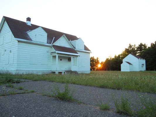
These beautiful features were encapsulated in over 73,000 acres of pristine woodlands marred only by a few, well-maintained dirt roads leading to the trail heads which accessed the features. To Chris it was a veritable photographer’s playground but she could not jump right in due to a commitment of Jay’s. His 50th high school reunion was scheduled for the weekend after their arrival and they decided it was best for him to attend without her so that she could catch up on some much needed work on the blog and photo editing. So the first few days of their stay they drove to a few of the falls within easy walking distance from the road to gauge when was the best time of day to photograph them, and got a lay of the land in general.


Jay returned from his Reunion with a tired derrière from all the solo driving, but was happy he got to see friends and classmates again; some for the first time in 50 years. He was shocked at how quickly the years had passed and how old they all had become. He was pleased that the years had not affected him as it had the others. [Yeah, Right! ;-).


With Jay (and the truck) back it was time to get busy and see the sights. An afternoon was spent visiting the Grand Sable Dunes. A detour near the end of the trail that led to an overlook terminated at the top of an old log slide that was used in the late 1800s to quickly transport felled timber down the 300 foot long slope to vessels waiting on the Lake. A caution sign, complete with photo of an ambulance, explained that if one chose to descend the slope they could but warned that people with heart conditions may have difficulty ascending as the 300 foot vertical drop was actually 500 feet of soft, sand and although it only took minutes to get to the bottom it could take an hour or more of considerable effort to return to the top. Chris and Jay were tempted to run down the log slide but the thought of the ascent quickly dispelled the idea.


The buff-colored sand of the dunes contrasted starkly against the Caribbean blue-green water of Lake Superior making for interesting abstract compositions that Chris just had to capture so they made their way over them stopping occasionally to set up the camera and play with the pixels. She and Jay were admiring the brilliance of a massive, white cumulus cloud that made its way over the dunes when the sunny area where they were standing suddenly went into deep shadow. The brilliant cloud was the leading edge of a dark, sinister looking cloud bank that surely had “bad storm” written all over it and they made a hasty retreat to the truck.


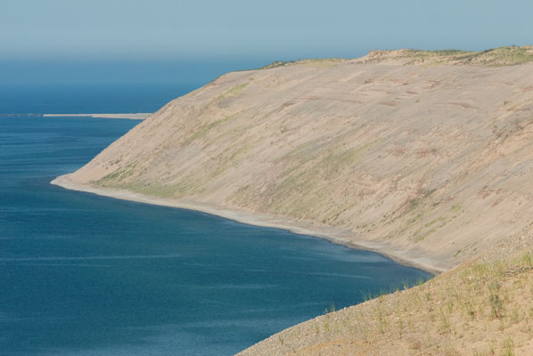
The contrast of the water and sand was breathtaking.


Since they were restricted to the vehicle for a while they decided to drive the short distance further east to the town of Grand Marais to see what it was about. Upon arriving at the town jetty, the heavens opened and torrents of rain reduced visibility to a matter of feet. A man standing on the porch of a nearby house waved at them and Chris waved back. Moments later they realized he was trying to get their attention. It seems he lived in the town, had taken an evening walk and took shelter from the storm on the porch. He was seeking a ride home as he didn’t know how long the storm would last. The torrents abated somewhat but his dash to the truck wasn’t fast enough to keep him dry.


He was a wealth of information about the town as they slowly drove away from the jetty past an old Coast Guard building and down toward the local marina on the way to his home. By this time the rain had stopped and a double rainbow arched from one side of the harbor to the other. Not knowing how long it would last, Chris dashed out of the truck with point-and-shoot in hand and snapped away. They lingered, absorbing the moment, until it faded then continued through the town, their guest spouting information as they went.


Notice the fainter rainbow to the right.

Both of them stretched completely across the harbor making a perfect double arch.


They pulled into his driveway at the end of a sparsely populated residential area while he told them about the bears he occasionally saw meandering through his yard and how the former owner of the home that, over several decades, had assembled a rock collection that sold for over $10,000. With the setting sun beckoning, they said goodbye to their passenger and headed for the lake to scout the best location to capture the colors and reflect on the events of their unusual day.


When severe storms roll through, brilliantly clear skies and strong winds normally follow and the next day was no exception. The gusts make it difficult to capture long exposures where foliage is involved but the frothy waves it creates are spectacular. Such was the case on their next day’s adventure to Chapel Rock, an unusual sandstone formation, which is found on the shoreline at the end of a three-mile trail. The inviting but chilly, fresh, blue-green water rolled into shore via pure white, capped six foot high waves. The contrast of a crystalline blue sky, jewel tone waves and golden sands was breath-taking. Chris wasted no time in discarding her shoes and socks, setting up the tripod in the surf and capturing all of the views possible for the next few hours.


The waves pounded Chapel Rock.


Additional hikes on the Beaver Lake trail, where they found the cutest, tiny, orange mushrooms just inches from the path, and the aptly named, Mosquito Falls trail, plus a surprise, afternoon visit from Merrill and Mona Wood filled the remainder of their time at Pictured Rocks. Chris was loath to leave not only the location but the near perfect weather. But, due to problems with the renter making payments, they had to start their way south to ultimately arrive back home in Maryland after Labor Day.


This cute cluster of mushrooms was right next to the trail and the largest only about 2 inches high.


They reluctantly left Munising on August 9th. The transition on the drive south was somewhat disappointing as the beautiful, lush, greenery of the Upper Peninsula gave way to the dry, dusty, flat terrain of Mackinaw City where another chapter of their travels would unfold.

Friday, December 3, 2010

Copper Country Capers

Copper country’s bounty is not in its copper but in its beauty. The peninsula is dotted with small, historic towns, waterfalls, lighthouses and homes, ranging from quaint cottages to modern villas, line the shores. The coast is scenically rocky with pristine beaches in shallow, protected coves. The northern tip contains snug harbors where boaters can take refuge from the unexpected fog that rolls in from the lake’s cool depths. Chris and Jay spent hours traveling the roads beyond Calumet through Eagle River, Eagle Harbor, Mandan, Phoenix, Mohawk, Bete Grise and Gay.


One day they drove to Copper Harbor at the northern tip of the peninsula and toured Fort Wilkins State Park. It was created in 1844 to protect the miners from Indians. The Indians in the area were migratory and only came to the northern coastal areas in the summer to hunt and fish. Since the mining took place in the central part of the peninsula and most of the supplies the inhabitants needed arrived by ship or rail, the Indians didn’t feel threatened and were never a hostile presence. The fort was abandoned a few years after its creation.


Some of the buildings at Fort Wilkins State Park.


Situated on an inland lake, the overall size of the complex was reasonably small as there were less than 100 men assigned to it when it was active. The adult and child employees dressed in costumes of the period and spoke as if they lived there. The children were barefoot and played games in the central compound, while two young women sat in one of the enlisted quarters cabins, complaining about the long, cold winters they had to endure and how they had to go all the way to the harbor for water because the fort slaughter house made the lake water just outside their cabin unfit for consumption.


A young girl in costume.


Always on the lookout for hiking trails Chris found the Estivant Pines Nature Sanctuary noted in a brochure local to the Copper Harbor area. The directions took them down a rutty dirt road deep into the woods where they found, to their surprise, ample parking! The 500 acre tract sanctuary is home to 300 to 500 year old, three to five foot diameter White Pine. In the 1970s the Michigan Nature Association bought the land saving the ancients from a logging fate. Two loop trails took them through the home of these giants. At first there seemed nothing unusual about the forest - it was just trees and undergrowth - until they began to look closely at the diameters of some of the trunks. Their gazes followed the massive wooden pillars skyward to the top branches towering over all other forest life. Humbled by their magnificence, Chris and Jay were grateful that these specimens had been spared from the “take no prisoners” policies of the 19th and 20th century lumber trade.


Chris and one of the monstrous White Pines.


Jay had remembered a high, scenic road that he had driven with his parents when they visited him in the 60s. The Visitor Information rag identified it as the Copper Country Trail National Scenic Byway. They found it began at Copper Harbor and wound up the nearby hills, followed the top of the ridge and afforded sweeping views of Lake Superior to the west and gently rolling terrain dotted with lakes to the east from the numerous scenic overlooks. West Bluff, the highest point, was completely unprotected and they almost had to lean into the wind to stay upright while they walked around the loop road to read the signs and absorb the sublime views. The heavy, carved, wooden signs posted near the road informed them, among other trivia, that they were 726 feet above lake level and 1,328 feet above sea level. Not a bad ski run distance if you could handle the winds.


View of Copper Harbour from the Scenic Byway.


On another day’s drive they discovered Lake Linden, located southwest of Calumet. It sat at the north end of Torch Lake and retained the 19th century historic buildings on the main road through the heart of town. They stopped for lunch at the Lindell Chocolate Shoppe, an adorable café with the original 1920s décor of patterned tile floors, wooden booths, with juke box music selectors and stained glass wall lamps at each booth. The original wooden juke box stood centrally against the back wall. Memorabilia of days gone by, probably collected over the 80 years of continuous operation, were housed in built in glass cabinets covering one side wall near the front of the café. Chris was surprised to find a (mostly) vegan sandwich on the menu which was delicious and Jay sunk his teeth into a plate of an open-faced beef sandwich smothered in gravy with mashed potatoes – his meat fix for the week.


The ornately decorated wall at each booth with stained glass shade and juke box selector.


After lunch they continued south and discovered Tamarack City, the location of the Hungarian Falls listed in a guide that they could not find because the town wasn’t on any of their maps! Chris had been anxious to find it because the photograph in the guide looked so wonderful that she just had to try her hand at capturing it. They found what they believed was the road to the falls, parked and, equipped only with hiking boots, hats and point-and-shoot camera, began to hike around and around and around searching for the falls. (They started out so sparsely because Chris wanted to see the falls and confirm they were worth photographing before lugging all of her camera gear there.) Eventually they took a trail that led them back down the hill toward the town where they cut through a wooded area and located the stream. It was shallow and strewn with enough rocks and low banks that they started to hop from rock to rock, crossing the stream dozens of times as they made their way toward where they hoped to find the falls. After their experience at Siskiwit Falls they loved the idea of actually hiking through the water, but this time they didn’t have their sandals on and had to work a bit at staying dry. They could hear but not see the fall as they arrived at an area strewn with large boulders, fallen trees and deeper water. Deciding that the going had finally gotten too rough they were lucky enough to find a path up the steep hillside adjacent to the stream and it led to another path that followed the ridge to the falls. They were worth photographing but the trail took them to the top of the main fall and it was evident that it was only clearly visible, and therefore photographable, from the stream 50 feet below. A short distance further up the stream was a second, smaller, and actually more beautiful fall and beyond that a man-made dam created a fair sized pond. Content that they had adequately explored the stream’s meanderings Jay and Chris found a road leading away from the falls which took them to where they should have parked in the first place. It was decided that they would return the next day, fully equipped with water wading sandals and camera gear to photograph.


Some of the myriad of stones they stepped on while working their way up the stream.


The trip up the stream in sandals wasn’t quite as much fun as the day before because of the extra weight and bulk of the backpacks. To steady their balance in the rough areas, Chris used the tripod and Jay an adjustable walking pole. Persistence paid off and they emerged a little wet but triumphant at the base of the lower Hungarian Falls. The water flow wasn’t as profuse as the guide photograph but then again it was mid-July and the snows which provided that volume had melted months ago. Chris actually preferred the lighter flow as the water cascaded down layer after layer of rock creating multitudes of mini falls rather than one giant torrent. She located a slippery, narrow, knob of earth about 20’ above the water which provided a reasonably unobstructed view of the fall, set up the tripod and camera and, praying that it was all worth it, snapped away. Jay was content staying waterside with his magazine and reluctantly ascended the slippery slope to occasionally hand needed gear to Chris. When Chris had finished photographing they picked their way downstream through the boulders and fallen trees to the path they had ascended the previous day and set up at the upper falls. Chris spent more time photographing at this location as there was a greater variety of views while Jay found a comfortable rock at just the right height to sit on and settled in to read his magazines. Time passes quickly in such beautiful locations and with digital cards filled with a variety of views and the sun nearly setting they headed home chatting about the wonderful days they’d just experienced.


Upper Hungarian Falls

Saturday, November 27, 2010

More Than We Ever Wanted to Know About Mining

The Keweenaw Peninsula was home to one of the largest copper mining industries in the nation from the 1840s through the 1960s. The town of Calumet was the home office of the Calumet and Hecla Copper Mining Company which is now the Keweenaw National Historic Park. The town and park have an unusual partnership to preserve the area’s history. The Mining Company office, home of the owner, library and a few other buildings are owned by the National Park. Many other buildings throughout the town are privately owned but are in partnership with the Park and preserved for historical and tourist purposes. Jay and Chris were so intrigued with the history of the area that they spent several days following the walking tours outlined in the park booklets visiting the historical buildings and learning all about mining in the 19th century.


Jay standing in front of a 9,392 lb. Float Copper which is created by glacial action tearing it from the veins as it scrapes the earth’s surface.


The Company buildings of the National Park were beautifully restored but unusual in exterior appearance. Irregularly shaped waste rock from the mines, in shades of brown, black and white, was the primary exterior material with building corners, chimneys, and window and door frames trimmed in red brick. Although unique and economical, Chris didn’t think it an attractive material for buildings owned by such a wealthy company although the architectural features were.


The main administrative building of the Calumet-Hecla Mining Company.


They toured the Coppertown Museum and learned all about the mining drills, tram cars that carried the ore out of the mines, the helmet mounted lighting systems and the pattern shop. Displays explained how workers migrated from a dozen different countries to work the mines, open stores and found churches in town.


A miner’s hat complete with candle for illuminating the work area.


Rusting hulks of mining cars used over the years.


Copper was discovered in the Keweenaw Peninsula in 1843 and by 1849 the area’s dozens of mines provided 85 percent of the entire United States’ copper needs, exceeding 11 billion pounds of the mineral over the next hundred years. The process required thousands of workers both under and above ground working around the clock. Calumet and the nearby town of Laurium, where Jay lived and where the wealthier employees and merchants lived, grew in population by the tens of thousands. The Calumet and Hecla Copper Mining Company provided housing, schools, medical care, a library and many other services for its workers and their families.


Jay standing in front of the house he lived in when he lived in Laurium.


But the services didn’t lessen the gruelingly hard work and inhospitable environment created by the industry. The conditions the miners experienced were brought to life for Chris and Jay when they toured the Quincy Mine just outside of Hancock. The mine shafts were poorly lit, and ranged in temperatures from the low forties several hundred feet down to the high nineties at the deepest levels of one to two miles below the earth’s surface. The air was thick with smoke from the many boiler houses which provided the power to operate the tram cars that climbed the shaft full of ore laden rocks, then when emptied descended for another load. Smokestacks from smelting buildings contributed to the lofty morass. The ground vibrated as charges were set off far below and the air was filled with the constant roar of big machinery as railcars brought coal to the boilers and left filled with ore for the smelting houses. The type of lives these people led is as distant to Jay and Chris as the moon.


The Quincy Mine Shaft house and the Brick Hoist House which powered the cables that raised and lowered the tram cars.


The clean, quiet but under populated town of Calumet is a much different place than in its prosperous heyday. The 19th century architecture remains and for the most part is in beautiful repair, but about ¼ of the buildings are unoccupied and its appearance is not unlike a ghost town where an occasional car is driven by or a solitary resident is seen walking their dog or a small group of children are seen playing in the spray of a fire hose as the firemen empty the truck’s water tanks into a lot occupied by a now boarded up elementary school.


The roads and parking spaces were sparsely populated.


The historic Calumet Theater.


Despite its sparse population the residents, shop owners and attraction volunteers love their town and are proud of their establishments. Chris and Jay ate in a couple of restaurants where the food was excellent and the buildings retained the charm of 19th century décor with patterned tile floors and high embossed, tin ceilings. One held a 30 foot long, walnut bar complete with a mural on the curved ceiling above depicting an 1800s dance scene.


A beautiful bar with mural painted above and patterned tile floor.


The Upper Peninsula Memorial Firefighters Museum, housed in the old fire station, was a rare treat. The volunteer in attendance grew up in the town and he and his wife return to the area in the summer and donate their time; he at the fire house and she at the Keweenaw Heritage Center at St. Anne’s Church. The station contained the most diverse variety of fire trucks Chris and Jay had ever seen. There was an 1857 Pumper, which was little more than a horse drawn, 10 foot long platform on wheels that held a pipe, and a pump which was driven by men raising and lowering two long, wooden rods on opposite sides of the platform. Nearby was a horse drawn sled with a cargo bed behind the driver’s seat which looked like it would have been used to transport hoses, buckets, ladders and other equipment needed to douse a fire. Along the back wall were hose reels which consisted of two, six foot diameter wheels connected by a drum onto which the fire hose was spooled. It was pulled by man or beast via a long shaft which extended forward of the wheels. The whole contraption was painted, of course, red. Chris got the biggest kick out of the hearse that was in the collection. The docent told her that it was used to transport the hoses (probably before they got those fancy two-wheeled things). The upper level held displays of water nozzles used over the years, framed news accounts of substantial fires in the community and photos of former firemen. But the highlight of the day was a round, canvas catch ring used to rescue people when they jumped from upper story windows of burning buildings. It brought back memories of old Charlie Chaplin movies and smiles to Chris and Jay’s faces.


The 1857 pumper.


The hearse amongst other fire trucks.


Jay with the Catch Ring.

Friday, November 26, 2010

The Land of the Yoopers

So far, the summer weather above the 45th parallel had been spectacular. Brilliant blue skies softened by scattered pillows of billowing, crystalline clouds and temperatures in the 70s had made the outdoor activities so far nearly perfect. On a similarly wonderful, early July day, Chris and Jay drove from Bayfield, WI to Hancock, on the Keweenaw Peninsula of Michigan. The 150 mile drive and time in the truck was a little long for their preference but frequent stops to stretch their legs, have lunch and gather a bag full of brochures, pamphlets and booklets from a Michigan Visitor Center broke up the several hour drive. They skirted the Lake Superior shore, following it south then east, along highways lined with thick masses of white, yellow, purple and orange wildflowers, their blossoms nodding this way and that in the gentle breeze. Jay grew more and more excited as he began to recognize landmarks and towns that he frequently drove through over 40 years before as a young enlisted man in the Coast Guard. His story of why he was there follows.

“In the summer of 1964, Jay returned from a year-long assignment at the Coast Guard LORAN (Long Range Aids to Navigation) Station at Port Clarence, Alaska located between Nome and Point Barrow. Since it was considered to be just about the very worst duty station in the entire Coast Guard (Jay agreed) he was given his first choice of new assignments. At this point you must remember Jay was only 21 and by definition “young and dumb”. Did he request Hawaii or some warm and sunny place on the mainland? No! He wanted to be near his parents, who lived in Greenville, Ohio so he asked for a shore station near them in Michigan. Now Jay was never considered a stellar student and Geography was definitely not his best subject in school. When asking for the Michigan station he didn’t know that Hancock was in the Upper Peninsula. In fact, he thought that part of the world was Canada and was totally surprised when he learned of his error. His wife at the time, Jo, did not speak to him for quite some time. However, the die was cast so off they went to live in the Keweenaw Peninsula, the most northern part of Michigan. That year it started snowing in September – Jay had really had his fill of the white stuff in Alaska and shoveling snow three times a day so he could get the car out of the garage and go to work was not fun – until he discovered skiing!!! All of you who know Jay very well know that he firmly believes there are only four things that are really worth doing and they all start with the letter “S”; skiing, sailing, scuba diving and s___. Jay’s 18 months in that part of the world was some of the most memorable times he spent in his Coast Guard career. Naturally, when he and Chris were thinking of a cool place to spend the summer and photograph, the shore of Lake Superior sounded like a good plan. As you can tell from the last few blogs it was and Hancock didn’t disappoint.”

As Chris and Jay entered the areas familiar to him, they detoured to the Indianhead and Powderhorn ski areas where he first learned to ski and which made life in such a cold, snowy land tolerable. Other than a few new buildings and some new chairlifts, not much had changed. The wildflower laden meadows of the ski slopes looked like colorful ribbons cascading down the mountains amidst thick, dark green timbers. All was silent except for the signs, suspended from weathered metal rods, creaking their resistance against the persistent, mountain-top winds. The buildings seemed abandoned but, they were just locked against vandals’ mischievous deeds until the winter storms blew in and energized the slopes with throngs of snow-lovers.

Further north they passed through Hancock where Jay’s electronics shop had been located in a battered garage the Coast Guard had rented before the construction of a new facility at the Station on the west side of the peninsula. He recognized a restaurant/bar that he and Jo had frequented. But, after more than 40 years, there wasn’t much else that was familiar. (since his home was in Laurium a 10 mile drive north.)

The McLain State Park where they were to stay for the next two weeks was about 10 miles outside of Hancock and the campground area was situated on a low bluff overlooking Lake Superior (and a perfect view of the sunset.) Below the bluff was a clean, sandy beach that stretched for miles around a shallow cove and frequently spaced along the grassy top edge were well-kept, painted, one-piece, wooden seating units consisting of a central tabletop flanked by two Adirondack style chairs. They were popular assets and one had to stake their claim early in the evening to have a front row seat at sunset (which, due to their location at the western edge of the Central time zone, didn’t occur until nearly 10 p.m.)


The view of Lake Superior from the campground seats.

This was the first Michigan State Park Chris and Jay had stayed in and they discovered that only electric hookups were provided at the campsite. There was a drive-through area where they filled Sonny’s 66 gallon water tank and hoped it would last the two weeks of their stay. Thus, much to their dismay, they were relegated to using the campground showers and water used in the camper for flushing, cooking, and washing dishes was kept to a bare minimum – think dribble. Thankfully the showers were spacious, clean, usually vacant and never ran out of hot water. Ahhh, the simple things in life that afford such pleasure.

After settling into their campsite, Jay was curious about the location of the Coast Guard Station where he had served. A trip to the park office and a conversation with one of the young men in attendance revealed that, although no longer in service, it was within walking distance; just west of the park’s property line on the canal. Several hours of daylight were left so Chris and Jay set off down a wooded trail to find it. The trail left the woods and opened onto a view of the canal. They passed a fenced enclosure which protected a tall, communications tower, which Jay suspected was currently used by the Coast Guard. They continued through another wooded area where they startled a peacefully grazing doe who made a terrific racket as she bounded out of sight. Then they saw it - just ahead in a clearing: The unmistakable, simple, white buildings with red roofs of a mid-20th century Coast Guard Shore Station. The windows were covered with plywood and overspray from a recent paint job splayed onto the red shingles in a broad, right angle where the windows rose above the roof. Jay was beside himself as he strode through the knee-high grasses and wildflowers to the buildings. He located the electronics shop where he worked while Chris took some snapshots of the area. They descended the still sturdy, metal staircase at the back of the boathouse and walked its length to the water. Aside from a hole in one of the large, work-bay doors, presumably from vandals, the buildings and grounds overall were in very good condition. Jay told Chris some stories of his time there; who he liked, who he didn’t and why. It was evident that even after serving over 24 years, 16 of which he flew helicopters, his time in the Coast Guard was very dear to him and his career too short.


The abandoned Coast Guard Station at dusk.


Jay in front of the Electronic Repair Shop where he used to work.

Although some may think that Jay and Chris are on perpetual vacation this is not the case. Bills need to be paid, groceries and other necessities need to be bought, the RV requires cleaning and countless other duties that one would normally do at home need attention. The first day at a new location is usually spent catching up on e-mails, finances and miscellaneous paperwork which is what they did. Their reward was to garner a lake-side chair, relax and enjoy the entertainment of fellow campers on the beach while basking in the warmth of the setting sun.

Jay pointed out a big splash several hundred feet offshore and remarked that it had to have been caused by a huge fish. A short time later Chris noticed another splash. They began to think it a strange phenomenon and sought an alternative cause. It was then that they noticed several boys, estimated ages from 10 to 18, with golf clubs and a large sack of balls below them on the beach. Three of the older boys were lined up at the water’s edge and were hitting the golf balls into the lake – causing a great splash of water where the ball landed! One boy was quite good and he was hitting balls the farthest making the biggest splash that Jay had first noticed. The balls other boys hit fell short in quality, sometimes skipping across the water like a flat rock or just barely becoming airborne for a few feet before plunging to the bottom. When they were out of balls they all piled into a 12’, flat-bottomed, aluminum boat and, standing upright, paddled out to gather them. The water was crystal clear and once a sighting was made one or more of them would jump overboard to retrieve the ball. This was done repeatedly by the younger boys while the taller, older boys would wade, chest-deep, through the area using their feet to feel for the balls, then dive down to pick them up. All-in-all, it was quite an unusual form of evening entertainment.


Some of the boys retrieving the balls.

It was probably a good thing that the days were so long as it gave Chris an opportunity to see the sights and to photograph the sunsets at the McLain State Park beach. A little south of the sandy campground beach was a point of land where the sand turned to smooth, rounded, softball sized rocks. Further into the water, larger rocks of various sizes and shapes showed themselves and made interesting foreground elements for Chris’ photos. Cloud formations permitting, she spent several nights at the point capturing sunsets using a variety of techniques to create different effects. Now the hard part – editing them down to the best ones to keep and market.


A sunset at the mouth of the canal near the park.