Tuesday, March 15, 2011

A Bridge Too Low

If you have been following Chris and Jay’s travels from the beginning, the title of this entry might sound ominous but, Fear Not and Read On!

They like to stay off the interstate highways when moving to their next destination and found a route from Alamogordo to Gila (pronounced heela) Hot Springs using scenic secondary roads through the mountains.  Chris had begun using their travel time to compose the blog and had her head buried in her work when Jay saw a sign stating: “Low bridge 22 miles ahead”.  He pulled the rig over and stopped in front of a Bureau of Land Management sign.  Figuring they would have record of the bridges on their land, Chris located a phone number for the local office and called.  Louis tried to be helpful but the task was beyond his pay grade.  The bridge was 4” lower than Sonny.  With the sun’s progress west, and considering their past trials, Chris and Jay decided to back track and be safer than sorrier.  No new learning experiences for them that day.

They had wanted to stay at Gila Hot Springs because it was only a few miles from the Gila Cliff Dwellings National Monument, built in the 13th century by the ancient Mogollon Indian Tribe.  The detour to stay in Silver City turned their drive to the cliffs into a 44 mile, 2 hour trip along steep, narrow roads riddled with hairpin turns that climbed and descended the 8,000 foot peaks.  The views were spectacular as the pine laden mountains formed layers of ridges tapering to narrow valleys stretching far to the horizon.   The travelers were glad they had left Sonny in Silver City as the volume of diesel fuel required to haul the tonnage up and down the slopes would have set them back a pricy night out!


The gorgeous mountains of the Gila National Forest.


After a stop at the Visitor Center, Chris donned her camera vest and she and Jay got quite a workout hiking the narrow, unpaved trail to the dwellings.  The gentle ascent along the canyon stream was a cinch.  It was the steps and steep switchbacks that caused the heart rate to soar.  Fortunately there were some “viewing areas” along the way which provided a good excuse to stop and catch their breath under the auspice of taking photographs. 


Cave number 2 had one of the largest openings.


Margaret and her husband, John, were volunteering three months of the year at the Park and she eagerly led Chris and Jay through several caves commenting how she enjoyed talking with “interesting people”.  She explained how a room with bench seating cut into the rock and three-sided, rock fire pits in the floor, were thought to be used as kivas for tribal ceremonies, where the shaman supposedly lived, why some openings in the walls may have been created by vandals or falling rocks and that the tribe only lived in the caves for about 30 years – most likely leaving due to a decline in water supply.


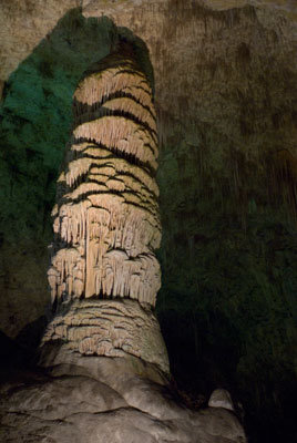
This two-story room may have been used for curing meats and tanning hides .


A “T” shaped doorway leading to one of the living areas.


She appreciated Chris’ desire to photograph the unique setting and told the story of a group she had guided sometime earlier.  A young woman wearing short-heeled shoes was in the group and when her boyfriend asked if she was going to take any pictures she replied that there wasn’t anything there to photograph!!!  She truly dwelled in a different universe.


Chris and Jay at the Cliff Dwellings.


The name Silver City conjured up a hodgepodge of images from the Old West and an afternoon was devoted to seeing how many of them were real.  Billy The Kid had lived in the town during his teens and the city had grown around the silver and copper mines that made some wealthy and sapped the life from others.


An 1870s style cabin that was built for the movie “The Missing”
and now sits on the Visitor Center property.


Man’s impact on the natural surroundings dealt an immense financial blow to the town in the late 1800s.  The massive timbering of the trees in the mountains and overgrazing of the lower grasslands left nothing to absorb the sporadic, torrential rains that plagued the area.  One day the town flooded and the turbulent waters swept away the entire Main Street, and soil down to the bedrock 60 feet below, taking all structures but one brick home with it.  The resulting gorge came to be known as The Big Ditch and thereafter commercial buildings and homes were made of brick and block and located at a higher level where they remain today and contain shops, artist studios, hotels and restaurants. 


A section of the gorge that was created during the flood.
The town created this Big Ditch Riverwalk Park to make use of the area.


Chris and Jay had arrived in mid-afternoon and were able to get a walking tour guide of the city, from the museum, which led them past buildings that originally housed saloons, banks, theatres and families.  One saloon contained a clinic where patrons could drink radium water, which was said to cure whatever ailed you.  This obviously took place before the dangers of radiation exposure were known. 


Some of the stairs at the street corners had tiles on the risers
with artwork and dates of when motion pictures arrived
or when businesses were founded.


By 5 p.m. most of the town had closed except for the eateries.  The hungry tourists found a local Mexican restaurant and, although the fare was a little bland, the price was right and they could check off having eaten at an authentic Mexican restaurant, while in New Mexico, off their list.


A true western sunset that greeted them when they left the restaurant.


Due to the Daylight Savings Time change that night, they waited until their arrival in Arizona, the next day, to figure out what time it was.  Since the Grand Canyon State doesn’t participate in the time change they didn’t have to reset their clocks upon their arrival at the infamous western town of Tombstone.

Monday, March 14, 2011

Snowy Desert

The mountains near Carlsbad Caverns were just a taste of what New Mexico had to offer.  On the way to Alamogordo Chris and Jay crossed over the Sacramento Mountains, whose 8,000 plus foot height peaks rivaled the Rockies.  Tall conifers replaced desert scrub and they were sure that the mountain top town of Cloudcroft existed solely to support a nearby ski resort where patches of snow were still visible on the second day of March.

The day’s journey was the first test for Big Red to haul Sonny up and down steep inclines.  Although Chris and Jay’s pucker factor was about an 8 on the way down the 6% slope, Big Red’s engine kept the rate of descent a consistent 45 mph and the brakes were pressed into occasional service to keep the twelve ton load under control around hairpin turns.

The mountains parted revealing a view of the valley below and Chris thought she saw clouds between them and the distant peaks.  In reality it was the pure white, rolling terrain of their destination – White Sands National Monument.   Chris squirmed in her seat at the anticipation of their visit.


A glimpse of the mountains they drove through.
White Sands is the thin band of white in the center left of the photo.


They started the trip relying solely on their trusty GPS which had done a stellar job of guiding them across the country thus far.  Jay had even printed directions from the Google Maps site as a backup and both directed them to the same entrance to Holloman Air Force Base where they would be camping.  Doubt as to their validity began to cloud the traveler’s minds as the GPS led them north, through a residential area and down a long, straight road terminating at a suspiciously militant looking gate topped with barbed wire.  A similarly crested fence stretched miles to either side and the guard building, Restricted Area signs and lack of life forms greeting them were clear indications that this was not the correct entry point.  Numerous others had made the same error and a wide area in the road enabled Jay to reverse direction.  Chris plugged in the correct gate’s street name into the GPS and in a short time they were settled in for the night.

Chris and Jay learned a valuable lesson during their stay: When the weather is good, go exploring.  The first day was a beautiful, warm, cloudless day with a soft breeze and, as predicted and expecting the rest of the week to be likewise, they hung around the trailer and caught up on personal affairs.  Although a bit windier than they preferred and expecting the rest of the week to be no worse, the next two afternoons were spent at White Sands scouting the area and taking a few photographs.   Then the wind started.


These dunes near the entrance of the Park are only about twenty feet tall.


Holloman AFB and the White Sands National Monument are located just outside of Alamogordo, New Mexico in a perfectly flat, fifty mile wide valley between the Sacramento and San Andres Mountains.  The lack of vegetation above knee height allows the southern winds to howl through the valley completely unobstructed, picking up speed as the day warms.  Dust, the consistency of baby powder, is propelled at tropical storm velocity permeating minute cracks and crevices and sandblasting all in its path.  Sunday’s wind was the worst.  For most of the day the view of a concrete block wall less than two hundred feet away was completely obliterated.   Sonny shuddered and creaked as the frame flexed against the pressure and tearing of the awnings covering the slides was a concern. 

The tempest gradually abated to the 20 mph range over Monday and Tuesday, but the conditions stalled all further photographing at the dunes and delayed their departure to the Gila Cliff Dwellings from Tuesday to Wednesday.

Everything happens for a reason and the gale descending upon them at that particular time was no exception.  Jay’s back was causing him problems and climbing sixty-foot high dunes was out of the question.   Chris provided therapy and he spent most of the day in bed, on his back, watching a day-long series of Indiana Jones movies.  To his surprise, a security gate scene in the, Kingdom of the Crystal Skull, looked identical to the Restricted Area gate they’d encountered just days before.  Funny how those things happen.

Despite the troubles, the dunes were extraordinary.  Engulfing 275 square miles of the desert valley, they range in size from a dusting on the ground to over 60 feet tall and are the largest gypsum dune field in the world.  During the rainy season, the gypsum is washed down from the mountains into Lake Lucero at the southwest corner of the dune field.  As the lake dries the gypsum crystallizes creating an alkali flat.  Environmental conditions of freezing and thawing and wetting and drying break down the crystals and the strong winds tumble the sand-sized particles scratching them into the snowy white sands of the dunes.

The graphical nature of the mounds, ripples, ridges and hollows are breathtakingly beautiful and the two days Chris and Jay spent exploring them just scratched the surface of what she’d like to capture.  A return when the plants are greener and in bloom is a must-do item on their travel agenda. 


A glimpse of what Chris found on the dunes.


The shadows were so soft and flowing.


In such a dry, desolate area one would not expect much more than the occasional patch of grass or scrub bush to grow but the valley is home to McGinn’s Pistachio Tree Ranch and Arena Blanca Winery.   Huge trees, mimicking a battalion at attention, covered hundreds of acres of the dusty, brown terrain and vineyards filled the spaces in between.  Miles of pipes provided drip irrigation to sustain life through the dusty, dry winters.

Jay’s back improved enough by their last day in the area to enable an afternoon jaunt to the nearby Three Rivers Petroglyph Recreational Area about 30 miles to the north.  The stop was recommended to them by a volunteer at the White Sands Visitor Center who impressed the importance of arriving when the sun was low on the horizon for the best viewing of the prehistoric carvings.  Chris and Jay got a late start and were wondering, with the price of fuel nearing $4 per gallon, if the trip was worth it but their worries were dispelled after a short time on the trail.  Everywhere they looked were pale carvings which stood out against blackish rocks.  The brochure stated there were over 21,000 of them that took over six years to record.   Jay scouted ahead on the trail while Chris scrambled amongst the rocks getting the best angle for each photograph until the sun dipped behind the mountain tops and the chill of the evening air signaled it was time to go.


Some of the more outstanding designs on the rocks.


This reminded Chris of the Chinese Yin and Yang.


They had some enjoyable chance encounters with interesting people during the week.  While on the dunes one evening, while Chris was setting up for a photograph, a man appeared in her field of view with a tripod.  In short order, two more men with tripods appeared coming from different directions.  At first Jay thought they were the same person but he moved from place to place too quickly.   Eventually they all converged around Chris’ tripod and they learned they were retired school teachers from British Columbia, CA on a two-week photo tour of the U.S.  Jay was in his glory now that he had an audience and they exchanged stories of adventures and places they’d visited while Chris focused on her work.  Contact information was swapped and all went on their way.

While at the Petroglyphs they ran into a couple from Pennsylvania.  When Chris and Jay returned to the truck they found a business card from the new acquaintances on the windshield with a suggestion of a place to visit near Sedona.  And a retired Coastie, whom Jay had spoken with earlier in the week at Holloman AFB, had left his card in the RV door at the campground.  The joy of seeing new places and meeting new people is the best part of their travels.

Calmer winds enabled them to depart further west and on March 9th, they headed for the Gila Cliff Dwellings located high in the Gila National Forest, about a four hour drive away.

Thursday, March 3, 2011

This Place is Cavernous!

The expansive nature of the American Southwest also applies underground.  The Carlsbad Cavern Visitor Center sits high atop a mountain in the Guadeloupe mountain range and overlooks a sweeping flat vista that stretches as far as the eye can see.  Inside visitors board an elevator that drops them over 700’ to the cavern floor.  The first day of Chris and Jay’s visit they took advantage of the rapid descent to tour the aptly named Big Room.  They walked one and a half miles of smoothly paved paths lined with stainless steel railings to circumnavigate the fourteen football field length cavern in which tones louder than a whisper traveled ¼ mile.  Over one hundred different types of light bulbs in nearly 1,000 fixtures selectively lit the multitude of ancient rock formations, casting just enough reflective light to detect details in the ceiling towering hundreds of feet above.

Post cards and ads for the cavern feature photos of the monolithic stalactites and stalagmites for which Carlsbad is famous.  They are impressive but the beauty and diversity of their smaller counterparts were of more interest to Chris’ camera eye.  Illuminated alcoves revealed hundreds of delicate soda straws in pale white and tawny tones reaching for the floor.  Some surfaces were covered by brown popcorn, a feature completely new to the visitors, while the gentle folds of draperies adorned others.  All of this beauty created over the millennium through the simplicity of dripping water.


An iconic stalagmite in the Big Room.


Popcorn.


The first day of their visit Chris had camera in hand but the dim light required such long exposures that it was declared a “scouting day” and she took snapshots of features she wanted to focus on during their return trip.  They wasted the remainder of the day driving a nine-mile loop road that snaked along the ridge of the mountain, then descended into a valley and finally emptied onto the Park’s main road.


A mountain along the Park road.


The distant Guadeloupe Mountains seemed surprisingly high for Chris and Jay’s perception of what the desert southwest contained, but they were rapidly learning the realities of the area as the day had dawned blowing gale force winds with 60 mph gusts.  The twisting and rutted gravel road slowed their progress to that of a snail, but from the warm security of Big Red’s cab they bounced along enjoying the mountain vistas and chatting about the force of water required to sweep the volume of softball sized rocks and small trees into the piles of rubble they found along the dry stream bed in the valley.  They were still not sure that they would call the terrain “beautiful” as the spiny clumps of prickly pear cactus, yucca, sotol and small green shrubs scattered amongst the brown grass was completely foreign to the towering oaks they left behind in Maryland.  But its rugged contrast had a certain appeal they could not quite put their fingers on.

The next day they decided to enter the cavern via the natural entrance - a hole in the ground over 50’ wide dropping into an inky abyss hundreds of feet below.  Their reasoning that they would enjoy seeing the area’s offerings while walking downhill in a fresh and rested state rather than attempting to ascent the steep path, huffing and puffing and concentrating on how bad they felt at the end of a long day.  They patted themselves on the back for such good headwork as the path zigzagged sharply down the sheer, vertical face of the entrance for hundreds of feet, then leveled out a bit before plunging down another wall, repeating the same several times throughout the descent.  Remember the floor of the Big Room is over 700’ down and they easily walked ten times that distance on the switchbacks.  The mile and a half long section of the cavern was plain in comparison to the decorative main chamber, but the ceiling, hundreds of feet above their heads, impressed upon the travelers how miniscule they are compared to nature’s grandeur.


The first few switchbacks at the natural entrance.


By closing time Chris had filled the camera’s memory card and happy, but a bit tired, she and Jay were some of the last to enter the elevator for the trip to the top.


Chris’ favorite photo of the day showing an alcove filled with soda straws.


They wished they had at least another day to visit Sitting Bull Falls and hike a trail in the Guadeloupe National Forest but over the past two years of traveling Chris and Jay learned to not pack too much sightseeing into short stays as the writing and posting of the blog and most importantly, the editing of photos, falls behind.  So, the last day of their stay the photos were edited, bills were paid, Red got some badly needed maintenance, and preparations for the next day’s departure to White Sands National Monument were made.

Tuesday, March 1, 2011

Remember The Alamo

Chris and Jay continued their journey through Texas like a stone skipping across a pond as they hopped from Houston to Austin to Wimberley and finally to San Antonio.  They took a chance at not making a reservation and were able to secure a campsite for two days at the Lackland Air Force Base RV Park.  They leaned that Lackland is the Cape May of the Air Force; a boot camp training base.  When they went about their shopping and sightseeing travels through the base, they encountered companies of children – sorry, recruits, marching in formation as they made their way from class to class.

The Alamo was originally built across the river from the town of San Antonio and served as a mission in the 1700s to convert the native Indian population into Christian, Spanish citizens.  Chris and Jay felt very strange driving past high rise office buildings into the heart of downtown San Antonio to find the six acre Alamo shrine.


The famous façade.


Many of the home and commercial buildings in Texas are constructed of a cream colored limestone and the tall stone wall surrounding The Alamo grounds appeared to be made of the same material, only weathered, aged and mottled with darker hues.  They learned that the church, known for its infamous, round-topped front facade, was only a small part of the compound where the battle for Texas liberty was waged.


A portion of the stone wall surrounding The Alamo grounds.


When the structure was abandoned by the church in the 1790s the Spanish Army moved in and built a huge drilling compound surrounded by a protective stone wall.  It is in this enclosure that the 189 brave men gave their lives to protect Texas from the self-proclaimed dictator, General Antonio LĂłpez de Santa Anna. 


A 3 dimensional sculpture depicting the entire grounds
of The Alamo at the time of the battle.
The chapel is at the upper right hand corner.


Some were born in town but most migrated from almost every state in the Union at the time.  European immigrants from Ireland, Germany, England and Scotland joined them, coming months and years earlier to start a new life and buy land for a mere 12.5 cents per acre; a price the Spanish government had used to entice settlement of the Texas territory in the early 1800s prior to the Mexican independence war.  Among them were two famous frontiersmen – James Bowie and David Crockett.  Bowie had married a local girl and, as was the custom, they lived in her parent’s home in town.  Crockett had been a member of the Tennessee legislature but left the State for Texas when he became dissatisfied with their politics.


Flags representing the states and countries from which the volunteers
came stand around the perimeter of the church interior.


General Santa Anna, Mexico’s elected leader, decided to change the governing structure from one modeling the United States, of individual States, to a centralist government with all power emanating from Mexico City – meaning Santa Anna.  (Sound familiar?)

Taxes and other restrictions were imposed and over time the Tejanos decided they wanted to become an independent territory.  They seized The Alamo and other military encampments racking up some early victories.  But the 189 volunteers were not enough to defend The Alamo against over 2,200 of Santa Anna’s men.

Beginning on February 23, 1836, the Mexicans bombarded the compound with cannon fire for 13 days.  Then, before dawn on March 6th the Tejanos fended of two charges before succumbing to the third.  The volunteers took over 600 Mexican soldiers with them in their struggle.

Their deaths were vanquished several weeks later when General Sam Houston defeated Santa Anna at the Battle of San Jacinto near present day Houston.  A treaty was signed and Texas became TEXAS thus proving the saying “Don’t Mess With Texas!”

The San Antonio River runs through the city of the same name and along its banks is the “River Walk” a menagerie of restaurants and shops that border a broad, paved walkway immediately adjacent to the water.  In fact if one was distracted from their intended path, one could easily fall in!  Next to the Alamo, it is THE attraction in town as it meanders five miles in an immense horseshoe.


A stairway leading from the street level to the River Walk.


Chris and Jay took a mid-day break and dined at The Rainforest CafĂ©; a restaurant Chris had always heard about but had never patroned in the D.C./Baltimore area.  The interior was elaborately decorated with faux stone walls, whose surfaces and ceilings were covered with artificial flowers, vines and greenery.  Life-sized chimpanzees and a tiger nestled amongst the foliage near them periodically came alive as they moved, chattered and roared during the meal.  The food was surprisingly good and thus fortified, Chris and Jay continued their exploration of the city and planned their departure to Fort Stockton the next day.

Messin' With Texans

The thing one sees the most, when in Texas, are signs stating; “Don’t Mess With Texas!”  Our intention on going to Texas was specifically to do just that – or at least mess with some Texans J

Jay last flew Coast Guard helicopters at the old Air Station on Ellington AFB near Houston, Texas.  He was there from 1978 to 1982 and has always said it was some of the best and worst times of his CG career.  He was the Operations Officer (possibly the best & most demanding job in aviation) and promoted to Commander while there but also divorced from his wife, Jo, of 18 years.  Jay was eager to show Chris, who has never been to Houston, his old stomping grounds.  The original plan was to spend 6 to 8 weeks there, during the winter, to avoid the colder northern weather.  Faithful readers of this blog know that their plans are rarely completed and to keep in this tradition Chris & Jay were only able to schedule 7 full days there.  So many people to see, things to do and so very little time – like life…

Arriving in cold weather on the 10th of February, Jay could only recognize one landmark as they drove through the south-eastern portion of the city to get to the RV park.  When Jay used to fly over the area immediately south of the Air Station there was only Clear Lake City (where he lived) and the Johnson Space Center.  Route 45 continued south through a very sparsely populated area to Texas City then continued over a long causeway to Galveston Island.  In the 29 years since Jay left the area it has grown to fill the entire void with people, malls, highways and TRAFFIC!!!  Now he knew where all the people from the decaying parts of the rest of the country have gone – Houston…

The few days passed quickly with warm weather arriving and Chris worked feverishly catching up the blog while Jay found his shorts, T-shirts and waxing equipment to make Big Red all bright and shiny again.  The evenings were spent having dinner with friends.

Jeff Reeves was with Jay on two of his three Icebreaker deployments and lives with his wife, Debra, in Galveston.  Thankfully they weren’t badly harmed by the recent Hurricane.  Dinner was great fun.  It always amazes him how quickly the years between visits disappear and the conversation picks up where it left off decades before. 

The next night Dan Huber and his new wife, Nina, joined them.  Dan was crew aboard Jay’s sailboat when nearly every weekend was spent with members of the Crabtowne Ski Club, sailing the Chesapeake Bay from Annapolis back in 1983 & 84.  Remembering good times is always fun. 

Bob Newlin and Dave Dickey were both young (oh, so young) enlisted guys at the Air Station and they remained in the area in civilian jobs.  They came over Monday night for several hours of serious laughter as the years faded away and discussions of badminton games, won and lost, were remembered.  Chris made her wonderful Chili but was somewhat intimidated by serving it to “Texans” so put a bottle of Tabasco Sauce on the table so they could season it to taste.  She was pleasantly surprised when they didn’t have to do anything to her Chili and even asked for seconds.

While Jay lived in Clear Lake he saw a local Chiropractor for his recurring back problems and they established a long and lasting friendship.  In fact, they always had so much fun telling each other jokes that when Jay was scheduled for an appointment the Doctor always blocked out the time for two appointments because he knew they would spend so much time talking he would exceed his time limit.  It was wonderful to spend some time with Ron Slaughter and his new wife, Blanka.

As the short time in the area was drawing to a close Jay was able to rally his aching muscles to get some wax on the front of the RV so the bugs would have a clean spot on which to splatter.  Meanwhile, his old friend and flying buddy, Bob Sainlar, recovered from a bad cold so he and his lovely wife, Suzanne, could meet for a ceremonial lunch at Frenchies, which was just about the only restaurant still left  from the old days.  Thankfully the food was as good as Jay remembered it and another enjoyable reunion with dear friends was had.

With firm plans to return next winter, for a much longer visit, Chris & Jay left on Friday the 18th with Chris still not seeing the Air Station, Space Center or much of anything else the area has to offer.  The Blog was caught up and Big Red and Sonny looked much better than Jay’s muscles felt…

Tom Shallue was another one of these “young enlisted” guys who worked and played with Jay in Houston.  He left the Coast Guard, married the loveliest Texas girl in the whole State and stayed in the area.  They eventually moved near Austin so Jay HAD to take a detour to see them.  Over the years Tom and Barbara had bought 5 acres in the “Hill Country” near Lake Travis, NW of Austin.  They assured Chris & Jay there was plenty of room to park Sonny on their property for the weekend visit.  What Tom neglected to mention was the trivial detail that the road access to their property could have been used as excellent training for all-terrain vehicle driving qualifications!  Now that Chris & Jay have gotten in and out of there they have a whole new respect and appreciation for Big Red’s 4-Wheel Drive and raw diesel power.  Aside from that minor “thrill” the weekend was most enjoyable.  


The house that Tom built – literally with his own two hands.


They got to meet some new, neat friends of Tom & Barb’s (Robert & Shari Duncan) and all 6 of them went dancing on Friday Night.  Jay lasted only 2 dances before the smoke and loud music drove him out.  The term “Fuddy Duddy” comes to mind but being in the quiet out-of-doors is much preferable to large noisy crowds in smoke-filled rooms.

It is a little unusual to find “Coasties” in the middle of Texas but Jay also had another guy he was stationed with in San Juan, Puerto Rico way back in 1972 who retired just a few miles from Tom & Barb.  Don (Abe) Lincoln and his wife, Kathy, came over Saturday and they all ate too much, laughed and talked well into the late night hours.

When Jay lived aboard his boat, MOOREA, in the Caribbean he had 20 cooks in the 12 years he chartered his boat.  One of those cooks, Suzy Denby, lived in Austin and Jay met her and her very impressive young son, Wally, for lunch on Sunday.  Jay has to be one of the luckiest guys in the world to have so many wonderful people to hang out with.  He loves keeping up with old friends and meeting new ones.  Life is so good…


Suzy and Jay in front of Jay’s favorite fast food restaurant – Schlotzsky’s.


Sunday evening was spent with the 4 of them quietly chatting on Tom & Barb’s very comfortable porch then watching a movie in their imitation IMAX theater in their basement.  Tom beams with pride when he tells people he got that 80-something inch, huge TV on Craig’s list for $400.  What a wonderful weekend but it all had to end with our Monday morning departure heading to San Antonio.


Tom and Barbara Shallue on their front porch.


But wait, there’s more…  About half way between Austin and San Antonio there is the little town of Wimberley.  Guess who lives there?  Yep, another Houston Air Station Coastie.  They had just moved into their lovely retirement home on 5 acres complete with a covered RV parking spot next to their outbuilding (somehow barn just doesn’t do that beautiful facility proper reverence).  Milton (Uncle Milt) Thompson and his new wife, Karen, treated the weary travelers to the hugest steaks Chris & Jay had seen this side of the Pecos (a little TX lingo here)!  One can imagine that by this time Chris had heard just about all the Coastie war stories she could stand.  Thankfully, she and Karen could insulate themselves from the two “old farts” and talk about something more interesting than when Milt threw Jay over his shoulder, when Jay was promoted, and carried him to the helicopter wash-rack, strapped him into a litter (used for hoisting patients into the helicopter) and hosed him down after Jay had been thoroughly drenched with several large buckets of ice water.  Oh, the joys of military life…


Milt and Karen Thompson with Jay.


Deer that frequent their yard.


The next morning came all too soon and again promises of return visits next year for a longer stay were made.  A pleasant drive to San Antonio completed their whirlwind tour of catching up with dear friends.  One may think that driving about, seeing friends and eating vast amounts of food is easy but Chris & Jay were exhausted and needed a little rest.  You, dear reader, may feel sympathy for them at any time.