
Glen Canyon Dam and a section of the Colorado River canyon.
Chris was so excited to arrive at Page, the home of the Navajo Reservation, Antelope Canyon, The Wave and many other neat rock formations to photograph. Unfortunately, she learned that professional photographers need permits to photograph in Antelope Canyon, which can take two weeks to acquire from the Navajo Film Office, and some of the other more remote locations in the Vermillion Cliffs area required access permits from the Bureau of Land Management (BLM) offices as they limited the number of hikers each day to minimize the impact on the sandstone treasures. So, she regrouped and, after two days of internet and local information research, discovered other areas that weren’t so difficult to access.
Page is within minutes of the Utah border and their first trek was to the White Rocks in the southern part of the Grand Staircase Escalante National Monument, in Utah. The road to them is not marked and the only way they knew about them was via a visit to the BLM Visitor Center where the helpful staff gave them directions to turn at mile marker 13 and follow the road 4-5 miles to “the gate”. In possession of this detailed information they set out for their afternoon hike with high expectations of capturing some unique photos.

A view from Page of Glen Canyon and the gray cliff level of
the Grand Staircase Escalante NM.
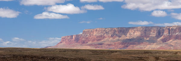
The semi truck in the foreground gives you an idea of the
immensity of the cliffs.
immensity of the cliffs.
Well, they found the road and passed through what might be considered several gates and after the allotted distance came to “The Gate” which was no more than a “U” shaped passage that allowed people through but not the cows who observed them from the other side of the fence. Donning hats and backpack and camera equipment, Chris reached for her camera only to find it wasn’t there. In the hustle to leave the RV and collect equipment, food, water, sunscreen, hiking poles, etc. the most important device had been left behind. In seconds her mood deflated from eager expectation to disappointment. Undaunted, they stowed “the gear” and with only the handy point-and-shoot, decided that it was a good day for a hike and ambled off determined to not waste the day.
The White Rocks created the northern border of a shallow, dry canyon occupied by a small scattered herd of cows and their offspring. The floor was covered in dry scrub and the hikers wondered what the bovines ate, much less drank. They followed a dirt road about a mile into the valley and came upon the unusual rock formations they’d anticipated. Some looked like wet, gray clay that had been whipped by beaters and left to dry into a stiff, swirly mound. Cliffs of petrified white sand, sporting web-like etchings from eons of summer rains, supported darker brown layers of stone, and irregularly pocked walls resembled Swiss cheese in the amber late afternoon sun. The relaxing hike and diverse sights were an ideal introduction to the offerings of the area and herding the cows was kind of fun too.

The White Rocks Canyon topped by another “step” of the Grand Staircase.

This formation looks like gray clay that has been whipped by a beater.

Petrified white sand etched by rivulets of rain.
The gorgeous weather of their first hiking day quickly turned foul with gray skies and gusting winds. They decided to stay close to home and drove the few miles to the iconic Horseshoe Bend. Chris was uncomfortable with the ideal positioning required to capture the view, sans foreground rocks, which entailed literally hanging the camera over the edge of the almost two thousand foot tall cliff, so she did the best she could with the lens that she had and they called it a day.

Chris would have preferred not to have the rocks jutting in from the left of this photograph but, you get the idea.
Jay felt compelled to complete several “must do” projects that had been plaguing him and he stayed behind a couple of days while Chris explored on her own. The horticulturist in her was intrigued by the nearby Hanging Garden, a rocky outcropping that sheltered fern, columbine and other shade loving plants from the intense desert sun and she decided to check it out. The expected green foliage turned out to be very sparse, with most of it brown and dry due to the lack of winter rain but she was entranced with the diversity of the surrounding rocks. The afternoon was spent capturing abstracts of sandstone above and below her and wandering the red, rocky terrain in search of unusual compositions.

Beyond these rocks resides the Hanging Garden.

One of her abstracts from the day’s meanderings.
The road from Sedona to Page ascends a sheer cliff across the valley from the easternmost side of the Vermillion Cliffs National Monument and when Chris and Jay stopped at the overlook, tears welled in her eyes at the surrounding beauty. Red faced mesas thousands of feet tall stretched before her as far as she could see and the green valley floor was slashed in two by the jagged canyon of the Colorado River as it coursed toward the Grand Canyon. On Jay’s second day of project catch-up, Chris decided to find out what the area had to offer photographically.
An idea of the vastness of the area.
This is one small portion of the Vermillion Cliffs.
Grand vistas are difficult to capture and convey to the viewer the immensity of what is before the photographer. That is why Chris usually focuses on the decorative and interesting details of the western terrain and she certainly had food for her photography fodder at Vermillion Cliffs. Fortunately the road at the base of the bluffs abounded with pull-off areas offering ideal vantage points for her lens.

one of the few places to cross the Colorado River.
As the sun tracked west and rocks reflected less light she happened upon a house of rock built in the 1930s by Blanche Russell. While traveling through the area in 1927 her car broke down and she was forced to camp overnight. She liked the scenery so much she bought property and built her home around a massive rock at the base of the escarpments. The roof had collapsed and only wood-framed holes remained where doors and windows once protected the occupant from the elements but to Chris it was her favorite type of subject – old and decrepit!! She snapped the shutter until the sun dropped and couldn’t wait to tell Jay what he’d missed!!

This tiny abode is built around the huge boulder visible at the top of the structure.
Big Red finally got to show his traveling buddies what he was made of when Chris and Jay decided to photograph Padre Bay on the north shore of Lake Powell. The overlook is accessed from a winding, rocky road that threads through terrain that seemed more appropriate for the moon. They cavorted up, down and around mounds of gray and yellow pumice-like soil that swelled around them as they pressed toward their afternoon destination.

They drove through miles of this moonscape terrain.
The pumice gave way to low scrub and then to bare rock on the peninsula near the bay. They resorted to 4WD low-range and Red expeditiously rose to the challenge of scaling foot-high rocks on a steep slope with Chris at the wheel and Jay out in front providing guidance. The road ended but the water far below them was not Padre Bay. Scanning the horizon they saw a road to the left ascending a distant ridge but nothing to connect them to it except a field of rock.
The outing had taken longer than anticipated and the sun was low on the horizon. Even if they managed to get to the bay, time would be spent photographing and it would be dark upon their return. Unfamiliar with the territory and without guidance the adventurers decided it was a little too adventurous for them to press on and reluctantly retraced their way home stopping briefly for Chris to photograph an interesting area she’d spied on the way.

A small section of the Lake Powell shoreline.
To the Southern Paiute Indians wahweap means cedar or pinyon pine canyon while the Utes defined it as salt canyon which is an apt description of where they found the Wahweap Hoodoos. Chris had seen photos of them and decided it was worth the 3.5 mile hike to capture for herself. The man at the BLM Visitor Center supplied her with a map which included photos of landmarks and she and Jay set out much earlier than usual to catch the morning light.
They lied. The people that made up the maps lied. Chris and Jay are not prime physical specimens but they are in better shape than most their ages and they do their fair share of walking. It would normally take them about 40 minutes to briskly walk two miles. They set out walking at 8:45 a.m. and by the time they reached the Hoodoos it was almost 11 o’clock! They met a couple returning to their car who said their hand-held GPS declared it was over 5.5miles one way. Since the dry stream bed they were instructed to follow squiggled through the valley floor like a sidewinder Jay surmised the 3.5 miles was “as the crow flies”. Unfortunately, the added miles delayed their arrival and by the time they reached their destination, the best light for the view she wanted had passed but Chris found other angles and the outing was salvaged.

The most iconic of the Hoodoos.
Their novice hiking legs manage almost without effort on flat terrain of 3 to 5 mile trails. But, more than twice that distance in hot, dry, desert conditions was laborious especially when they were laden with twenty or more pounds of photo equipment, water, snacks and clothing. On the return trip, rather than follow the long, winding path of the creek bed, they blazed trails through the scrub cutting off precious yards as their water was running low and each step was becoming increasingly more painful to toes, knees and hips. After what seemed like hours of tramping over river rocks and chaparral, Jay looked ahead and saw a bright reflection in the distance. It was Big Red’s windshield reflecting the sun like a lighthouse beacon guiding them home. It was well more than a mile away but the vision encouraged them forward. Finally they glimpsed a red roofline, then a door. They climbed up the creek bank and plodded the last 50 yards to “home” where they revitalized their exhausted bodies with food, drink and a place to rest their weary, dogs.
Fortunately they were not scheduled to leave for two days allowing them a day to recover and do something a little less strenuous – like cleaning Sonny. Then on Saturday, April 30th they made the three hour drive to Zion National Park and the land of “WOW”.