Tuesday, September 13, 2011

Moseying Through Montana

When Chris had planned their 2011 travels north she was smart enough to schedule down time after major photography stops and six days at Bozeman, Montana was just what they needed after all the driving at Yellowstone.   The RV Park where they stayed packed the transient guests into shade less, graveled sites like sardines and was sandwiched between the interstate on one side and very active train tracks on the other; complete with a nearby intersection which required passing locomotives to blow the long, short, long air horns at their approach.   Chris and Jay never knew what to expect when they arrived at a new Park and pondered adding “How close are you to train tracks?” to the list of questions they normally ask about price, cell service, and hook-up facilities when making reservations.

When checking into the Park on Friday, July 29th, they were told about a Sunday morning Farmers’ Market held at the Bozeman Fairgrounds.  Tired of the same old breakfast fare, Chris suggested they go out for a Sunday morning breakfast and attend the Farmers Market thinking it would give them a flavor of the area.

After so many weeks of living close to the earth and hiking Chris decided it was time to get gussied up for their trip into “the city”.  Hair was styled, makeup was applied, “going out” attire was selected and donned and she felt like a person she had known before but had somehow lost track of.   With map in hand, complete with locations of eating establishments graciously noted by the Park owners, the visitors eagerly headed into town for a welcome break from computers and long days of driving. 

They found the college town of Bozeman held more promise than the RV Park.  Late eighteen hundred style vintage brick buildings lined the broad, downtown Main Street echoing its early roots and clean, roomy, sidewalks bordered prosperous shops, offices and cafés.  They hopped out of Big Red and eagerly headed toward the location of several orange dots on the map signifying restaurants serving scrumptious breakfast fare.

They walked a few blocks and didn’t find the one they sought, so they crossed the street and doubled back seeking an alternative option.  Nothing seemed appealing so, thinking they had somehow missed the establishment, they crossed the street again and slowly scanned the storefronts and signs they’d previously passed.  Still no café.  Thinking the establishment had gone out of business, perhaps unbeknownst to the Park owner, they again crossed the street in hopes of finding something that would satisfy their growling tummies. 

After reading the menu in the window of a small coffee shop and not finding what they felt would satisfy their cravings, they turned to continue down the street when a woman, sitting at the establishment’s lone outdoor table with her husband, asked if she could help them find something.  Jay explained their quest and, in an instant, discovered the orange dot on the map was on the wrong block.  The discussion of directions turned into where each party was from, then why each was there, to introductions and exchanging cards with contact information.  Their new friends, Paula Milano and Eric Nielsen, then walked them far enough to see the café’s sign and they vowed to get together before leaving at the end of the week.

The meal at Main Street Over Easy did not disappoint and in fact exceeded Jay and Chris’ expectations of breakfast fare in a small western town.  But the delay in finding it, plus the time spent eating, left only an hour to take in the Farmers’ Market. 

Compared to the Fairgrounds near Annapolis and Baltimore, Bozeman’s was quite small.  And due to the minute percentage of produce stands vs. craft vendors, it seemed to Chris that it should be called a flea market or craft fair rather than a Farmers’ Market; but they found the fresh veggies she wanted and then some.   To Chris it was an opportunity to get some unique Christmas gifts.  To Jay it was about PIE!!  They sought and they scored!

After two weeks without a cell signal hundreds of e-mails needed attention, bills needed to be paid, laundry had to be washed and in general, the travelers enjoyed not needing to drive anywhere except to re-provision their depleted supplies.   Dinner with Paula and Eric was their only commitment and they all enjoyed it thoroughly.


A view of the Madison Mountain Range from Peets Hill/Burke Park in Bozeman.

 
___________________________________


In May of 2010 Chris corresponded with a former computer client, turned friend, about their plans to tour Montana that year.  (If you’ve been following the blog you know those plans were delayed until 2011.)   Chris’ friend knew a couple that lived in Deer Lodge, MT and suggested that they get together when they passed through the area on the way to Glacier National Park.  Several e-mails later an invitation to visit was extended by the Deer Lodge residents, Irene and Bill Fries (pronounced frees).   Not wanting to be an imposition on people they’d never met, and not knowing how they might get along, Chris arranged to stay only through a weekend.   On Friday, August 5th Jay maneuvered Sonny onto a level area of their front lawn while trying not to be distracted by the view across the valley of the majestic Flint Creek mountain range and the 10,000 foot Mt. Powell.  Irene and Bill were gracious hosts and the two couples found much in common to discuss and do. 


A breathtakingly beautiful sunset over the Flint Creek Range.

Irene is an avid hiker, but long treks do not agree with Bill’s extremities which keep him home working on improvements or woodworking projects.   Elated that Chris and Jay shared her outdoor interest, the three of them planned to hike the next day.   She took them to a trail that led to the Barker Lakes – one lower, the other upper.   The trail to the lower lake took them through open fields with spectacular views of the surrounding peaks, Lodgepole Pine forests and rock strewn meadows dotted with stunted trees but brimming with wildflowers of every color amongst  the lush, tall, vibrant  green grasses which are nourished by the turbulent lake-fed stream running parallel to the path. 


A patch of wildflowers along the trail.

After several miles they crested a hill and before them lay a mountain paradise.  Gray peaks, dotted with tenacious patches of snow, soared above a deep green skirt of mature pine and fir and wrapped around the lake like a protective, 4,000 foot high horseshoe.  The hikers longed to build a cozy cabin on the shore and live out the rest of their days in quiet, stress-free solitude.      


Chris and Jay at Lower Barker Lake.

Irene had a magazine article that explained how to get to the upper lake and Chris, more than Jay, was eager to help her find it.  The writer explained that trees with patches of bark removed were the trail markers to look for.  The hikers set out on a faint trail around the rim of the lake and turned inland where they thought the directions indicated.  At this point there was no trail but they pressed through rough, dead limbs and over errant rocks and rotting logs trying to find the bare spots on trees that would mark their way.  The directions indicated crossing a 100 foot wide rock slide and that a tree with a bare patch was visible on the other side.  Chris and Irene left Jay, who was tiring of the exercise, and scaled an almost vertical slope littered with boulders the size of a body ball to reach a level area that they thought might lead them to the lake; and maybe even spy one of the bare trail markers.  Nothing was sighted but dark storm clouds above the mountain peaks heading their way. 


Irene descending the rock slide.


Feeling their efforts were in vain, and much to Jay’s relief, they all trekked down to the lake and arrived under the shelter of some dense evergreens just as the heavens opened complete with bolts of lightning and rolling claps of thunder.   It was the Christening of Chris and Jay’s ponchos that they so dutifully carted around with them on every hike and Irene covered up with a beach blanket she kept in her pack.

The sky cleared and they made it back to the car unscathed but disappointed they’d not located the upper lake.  A search on Google maps revealed that it was on the other side of the mountain to the left of the lake and one had to skirt around the base of it to get to the other side.   If three, intelligent people couldn’t locate the elusive body of water, they determined that the article’s directions were misleading and the map grossly inaccurate.

The next day Bill joined them to spend the afternoon at the Grant-Kohrs Ranch National Historic Site located in Deer Lodge.  All that remains of one of the largest Montana cattle ranches is 1,600 acres and 80 historic structures originally used by founder, Johnny Grant, and subsequent owner, Conrad Kohrs, from the 1850s well into the 20th century.  In the Ranch’s heyday 50,000 head of cattle roamed over 10 million acres of western Montana, Wyoming, Colorado and Canada.   The visitors toured the monstrous home, learned about the role of the chuck wagon on cattle drives and even practiced throwing a lasso around a makeshift wooden horse. 


A Ranch Volunteer, who makes a stiff cup of coffee, stands next to the Chuckwagon.


Bill Fries watches Jay practice his lassoing skills.


The new friends all agreed that their time together was too short and Chris and Jay promised to spend more time when they next passed through the area.  On Monday, August 8th they departed for a four-day layover at Missoula, a few hours to the northwest.


_________________________________________________


Missoula was a much larger town than they had expected but Jay took advantage of the plethora of large, chain stores to purchase some items that he had coveted for some time.  When Chris is photographing he usually takes along a magazine to read and pass the time.  He’d finished so many over the last year that he was running out of the stockpile of back issues he’d accumulated and wanted to begin reading novels, but didn’t want to carry the weight.  An e-reader seemed to be the logical solution and he finally found one that suited his needs and price range in Missoula.  He also yearned for a cell signal booster since the signals, in the remote areas where they camped, often were less than three bars resulting in dropped calls and making internet usage painfully slow.  He was ecstatic to find one and couldn’t wait to get it installed.

Despite the nearby train, the large, grassy sites and profusion of flowers in manicured beds, throughout the RV Park, made Chris and Jay think that it was one of the prettiest in which they had stayed.  They learned that their neighbors, Gerry and Dee Vachon, agreed when they got together one night after dinner.   The spacious lawns between the sites were home to large shade trees and created an inviting location for several hours of casual conversation.  After dusk the temperatures chilled so they moved inside - just before the sprinklers came on.  Gerry and Dee stayed only one night and an Oriental family took the site the next day.  They were still sitting outside at the picnic table after dinner when Chris and Jay heard their surprised but playful screams when the sprinklers unexpectedly doused them.  Smiles creased the listener’s faces. 

Even though they thought the scheduled down time would enable them to complete long put-off projects, it was not the case but they were looking forward to their visit in Polson with Jay’s old Coast Guard buddy, Fletcher Brown and his new wife Yan Zi, whom he had met on a visit to China seven years before.  The drive from Missoula to Polson was another short day and they arrived at Fletcher’s Montana country home, overlooking the thirty mile-long Flathead River and the quaint town of Polson, the afternoon of Friday, August 12th .

Thursday, August 11, 2011

The Nation’s First Park


In January 2011, Chris & Jay decided to stay at Yellowstone National Park for three full weeks, allowing enough time for Chris to adequately photograph the plethora of gorgeous features it offered.  She was able to secure a three week reservation in July, at a campground inside the Park, which she thought was ideal since they wouldn’t have to waste fuel driving in and out each day.  With Yellowstone’s reservations made all others, for the summer, were scheduled before and after their time there.  The Camp Hosting commitment at Bryce Canyon ate into the first week of their reservation but they felt that two weeks was probably enough time to see and photograph most of the Park.  It was not to be.


The Park has 310 miles of paved roads in a figure eight formation.  Speed limits range from 25-45 mph and “bear jams“ frequently occur where droves of visitors park anywhere they can find along the narrow, two lane roads to view not only bear but bison, elk, and scores of other wildlife.  They sometimes block the through lanes and slow or stop moving traffic. 


The stopped vehicles were not the only things slowing traffic.  The bison in Yellowstone are as revered as cows in India and frequently amble down the middle of roads or cross individually and in herds – further slowing traffic.  They can even be found resting on the porch of the Park Headquarters building.


This lone bison, still shedding his winter coat,
 lived near the RV Park where Chris and Jay stayed.


Mid-day sun is usually the worst light in which to take stunning photographs.  Since neither Chris or Jay are early risers, they would usually head out in the early afternoon, find a location to photograph and wait for good light.  The size of the Park is overwhelming and Chris found it difficult to decide on where to go since, with few exceptions, she didn’t know what she would find there, in which direction the site might face for the best light and invariably there were many other places to visit along the way on which the mid-afternoon sun was usually illuminating at an unappealing angle.  She’d take snapshots, make a note as to the best time of day to return and move on in hopes of capturing something more appealing. 


Mountains on the east side of Yellowstone Lake.


They decided to take advantage of the poor light to investigate the camp host opportunities of which there were many.  Over the course of two weeks they visited several campgrounds and learned of three vacant camp host positions but could not penetrate the bureaucratic morass to find out what duties the positions entailed, if they were to be filled that season and what type of site and RV hookups would be available at the host sites. 


A cell signal for phone and internet connection was imperative since the campground where they were staying was void of such a basic necessity to their lifestyle.  During their stay, Chris and Jay had to stop at roadside pull offs to make phone calls and check their e-mail while they traveled around the Park.  One camp host-less campground had a killer cell signal but didn’t appear to have any electrical or water hookups and the ground pit covered by a large plastic lid displaying “SEWER” was not the kind of connection they understood.  Another campground had full hookups but absolutely no cell signal.  The third had everything – hookups, cell signal, close to a Park entrance where they could go to a nearby town for gas and other shopping needs – and one of the three camp host couples had left that day due to a family emergency and wouldn’t be returning.  But the Ranger in charge was either too overworked or didn’t care enough to accept friends of another host to fill the position and Chris and Jay were told he wasn’t receptive to people “dropping in” on him.


During the first week, the would be volunteers spent at least three days locating campgrounds, talking to existing camp hosts, about the duties, the hours they worked and who to contact to apply for the position and got absolutely nowhere.  They were stunned and frustrated at the situation.  It seemed that having willing people on site was not incentive enough to spur the staff into taking action.  After hours of their valuable time and gallons of fuel, Chris and Jay finally decided to give up and on their way out of the Park submitted their applications for the 2012 season.


The infamous Yellowstone Falls.


They turned their attention to seeing the Park and, until an afternoon storm rained them out and ruined the light, spent an entire morning photographing the upper and lower Yellowstone Falls from a variety of vantage points.  Another afternoon they headed for Old Faithful and stayed through three, ninety-minute spaced eruptions to capture the geyser’s brief displays in different light.  Chris wanted to duplicate a stunning image she’d seen on a postcard that showed the erupting geyser next to the setting sun shining through the silhouette of a tree.  She found the tree and with camera on tripod, adjusted the position to keep the setting sun in just the right place between the tree’s branches while she patiently waited for Old Faithful to erupt.   The mound before her showed more and more steam activity and she quietly urged it to “blow” sooner rather than later, but the sun dropped below the distant hills and no more than five minutes later, Old Faithful spurted her last show before night’s black veil descended on the area.


The Old Faithful complex with the famous Lodge to the right,
Old Faithful steaming to the left
and the Visitor Center above it. 


The hours sitting in the truck took its toll on their spirits and derrieres and by the second week Chris and Jay  longed for a day hike where they could get into some natural surroundings and truly experience the beauty of the Park from someplace other than a paved overlook.  They decided to start out with a short, flat terrain hike to a natural bridge.  A Ranger had advised them to carry bear spray and have it readily accessible any time one veered away from the popular paved areas.  Chris and Jay considered the fact that several weeks before a man had been killed by a Mama Grizzly protecting her cubs, and discussed how valuable their own lives were.  They decided they were worth more than the $50 canister of bear strength pepper spray and with it strapped to Jay’s chest, set out for the bridge.  But families with small children that frequented the trail kept up such a constant chatter that they wondered why they’d bothered.


The Natural Bridge


The late spring and excessive snows of the previous winter endowed the area with more moisture than usual.  Beautiful Indian Paintbrush and other wildflowers bloomed along the trail but after pausing for more than a minute the hikers became magnets for the monstrous mosquitoes that hungered for their blood.  The hovering masses seemed to be attracted to DEET laced repellant as if it was pheromone spray.  As much as Chris wanted to photograph the beautiful blossoms, neither she nor Jay could tolerate the barrage and only a brisk pace kept the voracious predators at bay.


Spectacular views of distant mountain ranges they’d seen while driving through Dunraven Pass compelled the hikers to take the trek up Mount Washburn, one of the tallest peaks in the Park.  Thirteen hundred eighty-four vertical feet separated the trailhead from the 10,243 foot summit but the trail was wide with a gradual ascent allowing Chris and Jay to keep up a steady pace despite the weight of camera equipment.  The path was fairly heavily travelled with tourists sporting all manner of footwear from flip flops, to sneakers to sturdy hiking boots.  Some stopped and told them of a herd of Bighorn Sheep they’d spied and others spoke of a bear they’d seen the day before giving the bear spray toting couple a warm, fuzzy feeling that they had the deterrent with them.


This female Bighorn Sheep was less than 10 feet from Chris and Jay
 as they hiked up the mountain.


Despite frequent stops for Chris to photograph, they tired at the 10,000 foot mark due to lack of oxygen, but a man-made structure at the top beckoned them forward and they persisted.  The reward was worth it.  The structure contained a large, south-facing room with tall, glass windows on three sides revealing an unobstructed view of the Absaroka Mountain Range in the east, the Tetons to the south and the Gallatin Range to the west.  With the exception of the Tetons, all that was visible was within the fifty-mile wide Yellowstone Park boundaries – a truly remarkable experience.  Chris peered through a large telescope in the corner of the room and laughed when she sighted a bear jam in Hayden Valley, an area they passed through almost daily, and frequently had road blocks due to the number of wildlife gawking visitors.


The goal.  The building at the summit with snow still present in July.


Jay befriended Ben, an American man and two, young, Belgian women, Caroline and Hanna, who were traveling the Park together and had hiked to the top via another trail on the opposite side of the mountain.  Caroline was wearing a short sundress which was completely inappropriate attire to keep her warm during their descent as the sun would set before they reached their vehicle and the whipping winds at the summit further chilled the air.  Chris loaned her a shirt to help warm her and they decided to all hike to Ben’s car and he would drive the shirt donors to their truck at the other trailhead.  Along the way they passed another herd of Bighorn sheep complete with resident male, a marmot who sounded a loud warning chirp and, fortunately, no bears despite Caroline’s desire to see one before she left the Park.

It was an interesting ride back to the truck with five of them piled into a tiny Honda Civic whose trunk was completely packed full of their camping equipment and personal items and a back seat partially filled with more personal items and hiking gear from the day’s outing.  Caroline sat on Hanna’s lap in the back seat with Chris while Ben and Jay commandeered the two in front.  Contact information was exchanged and Chris and Jay chalked up Belgium as another country from which they had met U. S. travelers.

On the way out of the North entrance to the Park the next day, the Montana bound couple stopped at the Park offices and dropped off their volunteer applications for a 2012 camp host position.  They were fortunate to catch the Volunteer Coordinator in the building and had a more positive conversation than previously.  She at least seemed receptive to them dropping off an application.  They left the area ready to move on and explore the next State and possibly find the ideal home or property, complete with snow-capped, mountain view that would draw them away from lands east.

Tuesday, August 2, 2011

Sir Percival Bryce

The schedules at major points of interest are usually packed with time on the roads and trails and activities from early morning into the night.  Zion National Park was a wonderful playground, that kept Chris and Jay continuously entertained and substantially increased the volume of photos on the computer,  that they stopped at a small town called Hatch, for a few days, before continuing on to Bryce Canyon National Park.


To get there required a short stretch of interstate highway then turning, at Cedar City, onto a winding, two-lane road that ascended a 10,000 foot mountain.  Desert sage gave way to tall pine and the bleached bark of leafless Aspen.  As they neared the summit the harshness of the past winter was evidently displayed by the broken trunks of Pine and Fir.  The heavy winds and snow had bent the supple Aspen trunks into groves of pale arches.

The travelers arrived at an overlook where, far in the distance, they viewed the West Temple of Zion amongst the expansive mountainous terrain of southern Utah.  Amid the other visitors were father and son bikers.  The former sporting a long, gray ponytail and ribbons from his Vietnam service; features that Chris and Jay more or less expected in such a character.  What they didn’t expect was the tiny, but adorable dog attached to the leash he was holding and the equally tiny pet carrier lashed to his bike.  He and his son were cordial and engaged in light conversation and Jay thanked the elder for his service.

The mountain summit was unexpectedly flat with broad, snow-covered meadows, stretching to either side of the road.  They passed the entrance to Cedar Breaks National Monument and wondered what it was.  Thankfully the descent was much more gradual than the ascent and they arrived in the valley town of Hatch in good spirits.


This is what they found during a day trip to Cedar Breaks.

If the remoteness of the location and lack of “attractions” wasn’t enough to keep Chris and Jay holed up in the RV during their three-night stay, the weather certainly did.  The night of their arrival the temperatures dropped, the winds roared and precipitation of all types prevented them from stepping outside for anything other than a trek to the office for mail and to do laundry.

Caught up on e-mails and photo editing, they arrived at Bryce Canyon National Park on a gloriously sunny, blue-sky day and took up residence at Ruby’s RV Park, a mere two miles from the Park gate.

Chris was so excited to be back at Bryce Canyon.  She had been there with her daughter, Jessica, in 2007 when they turned transporting some furniture, from her home in Maryland to Jessica’s in Oregon, into a cross-country trip.  Jessica enjoyed their first day there so much that she insisted on doing the half-day horseback ride into the canyon, which they both thought was spectacular - until the saddle sores set in the next day.


A panoramic view of Bryce Canyon.

The 8,000 foot elevation at Bryce Canyon took some getting used to in more ways than one.  Several inches of snow fell during the freezing nighttime temperatures and although most days were sunny, Chris and Jay had to bundle up against the cool mountain winds.  Minimal exertion caused shortness of breath in the thin air making their first few trail outings much longer and slower with frequent stops to ease the gasps and prevent the need for CPR.


A view of the hoodoos from the canyon floor.

On Sunday, May 24th, eight days into their two-week stay, Jay received a phone call from Kevin Evans, a Park Ranger.  He explained that one of the camp host couples didn’t show and couldn’t be contacted.  The Park was desperate to fill the position.  He had gotten Chris and Jay’s names from the camp host volunteer applications they had submitted at Zion and wanted to know if they were available until the end of July.  They were his thirty-first call!  Jay was taken aback at the request and shared the information with Chris.  They thought of the reservations already in place and how the commitment would change their summer and said they were interested and would get back to him.  Within minutes, Chris dug out the summer’s schedule and discovered the only deposit they’d paid was for the reservations at Yellowstone and all others needed just a phone call to cancel.  They eagerly accepted.

Within days they’d been issued uniforms, radios and keys and had moved into the Sunset Campground host site.  After two days of training, by their host counterparts, they were on their own and interacting with the hundreds of visitors that frequented the campsites.


The volunteers before the 4th of July parade.
Chris spent the morning decorating the Polaris ATV they used for campground rounds.

Bryce Canyon National Park has two campgrounds – North and Sunset.  Sunset Campground has about one hundred campsites in three loops; two for tents and one for RVs.  At the campground entrance is a registration kiosk and a service road that leads to a loop containing four full-hookup campsites.  The first was occupied by camp hosts Liz and Gary Seaman and the second by Chris and Jay.  The others housed their new boss, Kevin Evans and his wife, Cheryl, who also worked for the Park.  Bob and Eva Safranek, Visitor Center Volunteers, had taken up residence in the fourth campsite. Via various meetings they attended, to become oriented to the Park’s policies and personnel, they also met one of the North Campground hosts, Chip and Jill Hayes.  Over the weeks to come they all became fast friends, getting together in the evenings for birthday celebrations, happy hours and going away parties.

The camp hosts were advised to keep the radios on during their waking hours, carry them even during their days off and while hiking, to contact a Ranger in case a Park visitor needed assistance.  Unfortunately the real juicy stuff was on the Law Enforcement channel to which they did not have access, but the transmissions became an unending source of entertainment.  There was always an unusual situation which required a call to the Rangers; from overpopulated campsites and loud and even nude campers to canyon rescues, lost pets and, sadly, several deer struck by speeding vehicles.  But, not all radio traffic was “official”.  Chris wanted to share her birthday pies (that’s right, not cake) with the on-duty Rangers.  The word was quickly spread and all three arrived at the appointed time for the evening’s sweets.

The work schedule was a little longer and harder than the new volunteers expected.  Gary and Liz had been there for a month and liked a four day on/four day off schedule.  Chris and Jay enjoyed the four days off but by the end of four fourteen hour days they were a little bit beat.  The schedule required them to be up and dressed by 7 a.m., then make rounds of the campground at 8, and 11 a.m. and 4 and 8 p.m. when they recorded what sites were occupied and with what, i.e. tents or RVs; and the most fun job of all – cleaning fire pits!!  Campers peppered them with questions but most of all compliments on how nice the campground was, how clean the bathrooms were and how grateful they were for the answers to all of their questions – especially the ones about the bears.

A prominently displayed notice on the Registration Kiosk warned of bears and it seems people actually read it – above all the foreigners.  One French woman was particularly concerned and with a French/English dictionary in hand, expressed her fears to Chris who explained that since the Park initiated strict trash disposal and food containment regulations, bears had not been seen in the campgrounds but they had been spotted in remote areas of the Park.  To further allay her fears, Jay offered her $1,000 if she saw a bear.  Thankfully she didn’t.

The most memorable question of the season came from a visitor at North Campground when they asked Chip and Jill “At what elevation do deer become elk?”  Who cares what they answered, the question was priceless!!

An unexpected reward for interacting with the campers was FREE FOOD!!!  Sunset campground had a group site that was reserved every Monday night by Backroads.com a worldwide outdoor tour company.   They filled the site with white vans for transporting the road bicycles, tents and carrying all the meals they prepared for their guests each night.  Any dinner fare that was not consumed was offered to the camp hosts – which they eagerly accepted.  They were treated to scrumptious lasagna, garlic bread, a moist, brownie-like chocolate cake and sometimes salad, in such quantities that it had to be shared amongst their NPS neighbors.

One perk of volunteering at a National Park is the opportunity for various types of training.   Chris and Jay were able to attend a CPR/First Aid refresher course to update their certifications.  A short time later there was a call on the radio for people to assist in a rescue.  A young woman had sprained/broken her ankle while hiking in the canyon and the Rangers needed hands to help carry her out.

Weeks earlier Liz had asked if volunteers could assist with rescues and was told they could not unless they’d had training.  As a result, Chris and Jay never responded to previous calls.  Having just received the First Aid training, Jay decided to ask if they could help, figuring that he’d get turned down if what Liz said was true.  The Ranger in charge said they could use all the hands they could get.  Despite it being a day off, within minutes Chris and Jay were in uniform, supplied with food and water and out the door.

The pace the young Rangers set hiking down the steep switchbacks into the canyon had the volunteers panting and literally jogging to keep up.  By the time they reached the injured visitor her ankle had been splinted and she was ready to be loaded into the litter, a contraption uniquely suited to the task with handles fore, aft and on both sides and a bicycle sized pneumatic tire directly under the middle of it to support most of the weight.  All the handlers had to do was guide and stabilize.

Chris and Jay were apprehensive about matching the pace out of the canyon, but  were relieved to learn that the route out was down – to Tropic a small town nearby.   It was a longer trail but they would go faster and boy did they!  Later Jay said he felt as if his feet were hardly touching the ground!


The Rangers held a going away cookout for the camp hosts that were departing and their arriving replacements.  It is customary to give a gift as a token of appreciation for the volunteers’ time and contribution to the Park’s needs.  Chris and Jay were expecting the obligatory NPS coffee mugs, which they got, along with a beautiful hardbound Bryce Canyon coffee table book, but Chris giggled with delight when Jay opened the box to reveal a Prairie Dog stuffed animal.  The Utah Prairie Dog is an endangered species that resides in the Park and one of the meadows where they live is frequented by shutterbug tourists.  The stuffed animals are sold in the Visitor Center to raise funds for their preservation.


Attendees of the going away picnic: L-R Chip Hayes (camp host), Rangers Katheryn Sommer, Peter Christianson, Dan Fagergren, Caleb Janda, & Duane Poslusny; Jill Hayes (camp host), Ranger Tyla Guss and Kemper Toller (camp host).


L-R Ranger, Rayne Rohrbach, Vern & Jo (replacement camp hosts), Liz and Gary Seaman (camp hosts) and Ranger Virginia Thiel.


L-R Kevin Evans, Jay Crouthers and Cheryl Evans.

Each animal comes with a full-color frame-able certificate and owners are encouraged to name their new pet and register it.  Chris looked at the cute little critter sitting on her desk one day and the expression on its face screamed Percy!  She and Jay agreed it needed only a monocle to appear like a stuffy British aristocrat and played around with variations of the name.  They settled on Sir Percival Bryce; Sir Percival having been the Knight of King Arthur’s Roundtable that found the Holy Grail.


Sir Percival Bryce.

The six weeks of camp hosting passed all too quickly but Chris and Jay enjoyed the experience and decided to apply to other National Parks in the months to come.  Sad to leave Bryce, but eagerly anticipating almost two weeks in Yellowstone, they departed the morning of July 14th to re-provision during a brief stop at Salt Lake City before heading to the nation’s first National Park.

Friday, July 8, 2011

The Land of WOW!

It was an easy, short drive from Page, AZ to Zion National Park but nothing had prepared Chris and Jay for the magnificent view they encountered at the Park entrance.  The afternoon sun illuminated the sheer, jagged cliffs at the entrance to the narrow canyon and all Chris could say was “Wow!”

The steep, granite cliffs of Yosemite National Park are world renown, possibly from the magnificent images of Half Dome and El Capitan created by Ansel Adams.  Zion was not a Park that Chris and Jay were familiar with until a few years before but they feel that it rivals Yosemite in more ways than one.  Although a narrower canyon, there is an undulation in the cliff walls that offer interesting hiking opportunities and views of crimson sandstone cliffs thousands of feet straight up; their crowns a variety of flat mesas, jagged peaks and rounded mounds surging up and down the length of the canyon.  Some crests are white which blended into the rusty oranges, reds and browns of the lower cliffs.


A glimpse of the canyon from the West Rim Trail.
To get an idea of scale, the trees on the slopes are at least 20’ to 50’ tall.


The Park keeps traffic to a minimum via a free shuttle system that runs from early in the morning to late at night, with stops at all of the overlooks and trail heads, enabling visitors and hikers a broad window to participate in all the Park has to offer.   The adjacent town of Springdale also offers a complimentary shuttle service that traverses the single road to the Park entrance.  Between the two services, Chris and Jay hardly used Big Red during their entire two-week stay.  After settling into their campsite they immediately boarded a bus for a tour of the Park. 

A disappointment to them was the massive number of tent caterpillars that had stripped the Cottonwoods bare of their fresh, spring foliage.  They covered walkways and roads, crawled up the walls of the Visitor Center and campground restrooms, clustered atop the campsite number posts and dropped from treetops onto passersby below.  Chris spoke with the camp hosts about the problem and was informed that the Park’s policy was that they didn’t harm the trees and although they had sprayed to control the caterpillars in the past there was no money for spraying this year.  Chris’ background is in horticulture, and she battled the Gypsy Moth infestation that engulfed the east coast twenty years ago.  She knew that complete defoliation of a tree over three to five years will kill it.  Mature Cottonwood trees lined the banks of the Virgin River that traversed the entire Park, through Springdale and beyond.  If those trees died, and their roots no longer hugged the riverbanks, the raging torrents that swell the river each spring would cause devastating erosion and loss of untold dollars in property damage.

The Camp Hosts tried to arrange a meeting for Chris with the Park employee in charge of the grounds but she was away for training and wouldn’t return until after Chris and Jay departed.  It was obvious to Chris that the problem was not just in the Park and that Federal, State and Local authorities would need to coordinate an effort to eradicate the pests.  She prepared a report outlining the problem, the effects of not controlling the critters, and offered to assist in a future program to halt the devastation, which the Camp Hosts agreed to pass along.  Meanwhile she and Jay squished all that came across their paths in their own personal effort to assist.

Wildlife abounded in the Park and although they didn’t encounter any on their hikes, while waiting for the shuttle buses they spotted deer, fox and turkey almost every day.


This turkey was strutting his stuff for all the lenses pointed at him.


They settled into a pattern of photographing every other day; allowing time for Chris to edit the photos she’d taken the day before.  But, like most plans it was difficult to implement and long after their departure, many photos still sat unedited on her computer.  As much as she wanted to capture views at dawn, their late, sunset-light capturing schedule just didn’t enable them to depart the RV before late morning.  But they enjoyed the photo ops the day hikes afforded so completely that there were few regrets.

The vertical ascents of thousands of feet from the valley floor took some getting used to but, day by day and step by step, Chris and Jay could feel their leg muscles firming and their breath coming easier as they tackled ever longer and steeper trails.  The Emerald Pools trails were their first and the ones with a manageable vertical drop.  The series of trails led to several pools of water created by skinny, wispy waterfalls dropping a thousand feet or more in different places along the cliff’s edge.  As exotic as the trail name sounds, making one envision clear, green, water created by some phenomenon of the area, they were named for the green algae that collects in them during the warmer seasons.  It was evident to Chris and Jay that the real photo ops on this trail would be when the snow melts forced torrents of icy liquid over the ledges in showy displays of seasonal change.  But it was a good hike to get a taste of Zion.


A wide angle view from the upper-most Emerald Pool.


Most of the photos the travelers had seen of Zion were of visitors hiking in The Narrows.  It is reached via the famed Riverside Walk, a two-mile round trip, paved stroll over the flat terrain of the valley floor which ends at a viewing platform surrounded by sheer rock faces which “narrow” to a slot canyon.  The snow melt that spring was so voluminous that for weeks the river barreled out of The Narrows, at a torrential pace, carrying millions of cubic feet of sediment, collected along its path, making further exploration for Chris and Jay impossible. 


A portion of the Virgin River as it exits The Narrows.

Not all of Zion National Park can be reached from the main valley so, an hour’s drive was necessary to explore Kolob Canyon located in the northwest section of the Park.  The landscape was so different from Zion Canyon the area could have been hundreds of miles away.  Finger Canyons, created from eons of stream-caused erosion, sliced through the breadth of the massive, burnt orange escarpments. 


One of the finger canyons in the Kolob Canyon area of the Park.

Most of the trails, in this section of the Park, were rated moderate to strenuous so, Chris and Jay decided to do the short, flat, five-mile round-trip Taylor Creek hike, which led to the Double Arch Alcove, rather than the thirteen-mile treks.   When they arrived at the trailhead, the weather was heavily overcast with roaring winds.   Rain clouds threatened but had so far only dropped light showers.  They figured they would be snug inside a protective canyon and forged ahead. 


One of two settlers’ cabins along the trail.

Once inside the canyon they were protected from the winds but found they had to cross Taylor Creek repeatedly.  It seemed they were walking a fairly straight trail which traversed a winding stream.  Chris hardly slowed down at the crossings as she lightly stepped from water-washed stone to water-washed stone to cross the three-stride wide stream.  In contrast, Jay was like a little old man testing his footing on the rocks and planting his hiking poles solidly in the water before taking another step.

The showers increased in frequency and intensity preventing the hikers from making their destination.  Warnings of flash floods abound in the region and without knowledge of how much rain had fallen upstream, the steady rain spooked them enough to turn back.  Jay suddenly became much more skilled at stream crossing and in no time was keeping up with his bride.


Chris and Jay crossed Taylor Creek 46 times and didn’t even get to the end of the canyon.

The most memorable hike was the ascent to the West Rim Trail, considered a “Must Do” by the creators of a local trail guide.  The Easy Reference section of the guide also labeled it as having cliff edges and drops, blistering sun mid-day, and was “Stair Master” difficult.  Sounded like a good day’s adventure to Chris and Jay!  By the time they tackled it, late in their two-week visit, they’d toughened up quite a bit and were adequately prepared with plenty of water, hiking poles, sturdy boots and broad brimmed hats.  Frequent stops to catch their breath on the switchbacks eased the pain a bit but at the end of the day they boarded the bus home grinning with the self-satisfying sense of accomplishment that only a challenging experience can deliver.  Oh, and the views were spectacular!


The dip in the cliff face is where the switchback to ascend the mountain lies.
One can either continue up Angel’s Landing (on the right) or
hike to higher ground behind, which is not visible in this view.

Jay decided it might be nice to become Camp Hosts at the Zion campground and, before leaving the Park for points north, he and Chris submitted volunteer applications to host next spring.  Neither of them dreamt of the opportunity their applications would lead to a mere nine days later.


Tuesday, May 24, 2011

Turning to at Page

Page, Arizona was founded in the 1950s to house workers when the Glen Canyon Dam was constructed to provide electricity to Arizona and Utah.  Located near the northern border of Arizona, the dam spans the Colorado River canyon creating the Lake Powell Reservoir in the Glen Canyon National Recreation Area a 1.2 million acre wilderness where desert residents ply the waters with recreational power vessels of all types. 


Glen Canyon Dam and a section of the Colorado River canyon.

Chris was so excited to arrive at Page, the home of the Navajo Reservation, Antelope Canyon, The Wave and many other neat rock formations to photograph.  Unfortunately, she learned that professional photographers need permits to photograph in Antelope Canyon, which can take two weeks to acquire from the Navajo Film Office, and some of the other more remote locations in the Vermillion Cliffs area required access permits from the Bureau of Land Management (BLM) offices as they limited the number of hikers each day to minimize the impact on the sandstone treasures.  So, she regrouped and, after two days of internet and local information research, discovered other areas that weren’t so difficult to access. 

Page is within minutes of the Utah border and their first trek was to the White Rocks in the southern part of the Grand Staircase Escalante National Monument, in Utah.  The road to them is not marked and the only way they knew about them was via a visit to the BLM Visitor Center where the helpful staff gave them directions to turn at mile marker 13 and follow the road 4-5 miles to “the gate”.  In possession of this detailed information they set out for their afternoon hike with high expectations of capturing some unique photos. 


A view from Page of Glen Canyon and the gray cliff level of
the Grand Staircase Escalante NM.
The semi truck in the foreground gives you an idea of the
 immensity of the cliffs.


Well, they found the road and passed through what might be considered several gates and after the allotted distance came to “The Gate” which was no more than a “U” shaped passage that allowed people through but not the cows who observed them from the other side of the fence.  Donning hats and backpack and camera equipment, Chris reached for her camera only to find it wasn’t there.  In the hustle to leave the RV and collect equipment, food, water, sunscreen, hiking poles, etc. the most important device had been left behind.  In seconds her mood deflated from eager expectation to  disappointment.  Undaunted, they stowed “the gear” and with only the handy point-and-shoot, decided that it was a good day for a hike and ambled off determined to not waste the day.

The White Rocks created the northern border of a shallow, dry canyon occupied by a small scattered herd of cows and their offspring.  The floor was covered in dry scrub and the hikers wondered what the bovines ate, much less drank.  They followed a dirt road about a mile into the valley and came upon the unusual rock formations they’d anticipated.  Some looked like wet, gray clay that had been whipped by beaters and left to dry into a stiff, swirly mound.  Cliffs of petrified white sand, sporting web-like etchings from eons of summer rains, supported darker brown layers of stone, and irregularly pocked walls resembled Swiss cheese in the amber late afternoon sun.  The relaxing hike and diverse sights were an ideal introduction to the offerings of the area and herding the cows was kind of fun too.


The White Rocks Canyon topped by another “step” of the Grand Staircase.


This formation looks like gray clay that has been whipped by a beater.


Petrified white sand etched by rivulets of rain.


The gorgeous weather of their first hiking day quickly turned foul with gray skies and gusting winds.  They decided to stay close to home and drove the few miles to the iconic Horseshoe Bend.  Chris was uncomfortable with the ideal positioning required to capture the view, sans foreground rocks, which entailed literally hanging the camera over the edge of the almost two thousand foot tall cliff, so she did the best she could with the lens that she had and they called it a day.


Chris would have preferred not to have the rocks jutting in from the left of this photograph but, you get the idea.


Jay felt compelled to complete several “must do” projects that had been plaguing him and he stayed behind a couple of days while Chris explored on her own.   The horticulturist in her was intrigued by the nearby Hanging Garden, a rocky outcropping that sheltered fern, columbine and other shade loving plants from the intense desert sun and she decided to check it out.  The expected green foliage turned out to be very sparse, with most of it brown and dry due to the lack of winter rain but she was entranced with the diversity of the surrounding rocks.  The afternoon was spent capturing abstracts of sandstone above and below her and wandering the red, rocky terrain in search of unusual compositions.


Beyond these rocks resides the Hanging Garden.


One of her abstracts from the day’s meanderings.


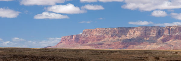
The road from Sedona to Page ascends a sheer cliff across the valley from the easternmost side of the Vermillion Cliffs National Monument and when Chris and Jay stopped at the overlook, tears welled in her eyes at the surrounding beauty.  Red faced mesas thousands of feet tall stretched before her as far as she could see and the green valley floor was slashed in two by the jagged canyon of the Colorado River as it coursed toward the Grand Canyon.   On Jay’s second day of project catch-up, Chris decided to find out what the area had to offer photographically. 


An idea of the vastness of the area.
This is one small portion of the Vermillion Cliffs.


Grand vistas are difficult to capture and convey to the viewer the immensity of what is before the photographer.  That is why Chris usually focuses on the decorative and interesting details of the western terrain and she certainly had food for her photography fodder at Vermillion Cliffs.  Fortunately the road at the base of the bluffs abounded with pull-off areas offering ideal vantage points for her lens.


The Marble Canyon area of Vermillion Cliffs are near the Navajo Bridge,
one of the few places to cross the Colorado River.


As the sun tracked west and rocks reflected less light she happened upon a house of rock built in the 1930s by Blanche Russell.  While traveling through the area in 1927 her car broke down and she was forced to camp overnight.  She liked the scenery so much she bought property and built her home around a massive rock at the base of the escarpments.  The roof had collapsed and only wood-framed holes remained where doors and windows once protected the occupant from the elements but to Chris it was her favorite type of subject – old and decrepit!!   She snapped the shutter until the sun dropped and couldn’t wait to tell Jay what he’d missed!!


This tiny abode is built around the huge boulder visible at the top of the structure.


Big Red finally got to show his traveling buddies what he was made of when Chris and Jay decided to photograph Padre Bay on the north shore of Lake Powell.  The overlook is accessed from a winding, rocky road that threads through terrain that seemed more appropriate for the moon.  They cavorted up, down and around mounds of gray and yellow pumice-like soil that swelled around them as they pressed toward their afternoon destination.


They drove through miles of this moonscape terrain.


The pumice gave way to low scrub and then to bare rock on the peninsula near the bay.  They resorted to 4WD low-range and Red expeditiously rose to the challenge of scaling foot-high rocks on a steep slope with Chris at the wheel and Jay out in front providing guidance.  The road ended but the water far below them was not Padre Bay.  Scanning the horizon they saw a road to the left ascending a distant ridge but nothing to connect them to it except a field of rock. 

The outing had taken longer than anticipated and the sun was low on the horizon.  Even if they managed to get to the bay, time would be spent photographing and it would be dark upon their return.  Unfamiliar with the territory and without guidance the adventurers decided it was a little too adventurous for them to press on and reluctantly retraced their way home stopping briefly for Chris to photograph an interesting area she’d spied on the way.


A small section of the Lake Powell shoreline.


To the Southern Paiute Indians wahweap means cedar or pinyon pine canyon while the Utes defined it as salt canyon which is an apt description of where they found the Wahweap Hoodoos.  Chris had seen photos of them and decided it was worth the 3.5 mile hike to capture for herself.  The man at the BLM Visitor Center supplied her with a map which included photos of landmarks and she and Jay set out much earlier than usual to catch the morning light. 

They lied.  The people that made up the maps lied.  Chris and Jay are not prime physical specimens but they are in better shape than most their ages and they do their fair share of walking.  It would normally take them about 40 minutes to briskly walk two miles.  They set out walking at 8:45 a.m. and by the time they reached the Hoodoos it was almost 11 o’clock!   They met a couple returning to their car who said their hand-held GPS declared it was over 5.5miles one way.  Since the dry stream bed they were instructed to follow squiggled through the valley floor like a sidewinder Jay surmised the 3.5 miles was “as the crow flies”.   Unfortunately, the added miles delayed their arrival and by the time they reached their destination, the best light for the view she wanted had passed but Chris found other angles and the outing was salvaged. 


The most iconic of the Hoodoos.


Their novice hiking legs manage almost without effort on flat terrain of 3 to 5 mile trails.  But, more than twice that distance in hot, dry, desert conditions was laborious especially when they were laden with twenty or more pounds of photo equipment, water, snacks and clothing.  On the return trip, rather than follow the long, winding path of the creek bed, they blazed trails through the scrub cutting off precious yards as their water was running low and each step was becoming increasingly more painful to toes, knees and hips.  After what seemed like hours of tramping over river rocks and chaparral,  Jay looked ahead and saw a bright reflection in the distance.  It was Big Red’s windshield reflecting the sun like a lighthouse beacon guiding them home.  It was well more than a mile away but the vision encouraged them forward.  Finally they glimpsed a red roofline, then a door.  They climbed up the creek bank and plodded the last 50 yards to “home” where they revitalized their exhausted bodies with food, drink and a place to rest their weary, dogs.

Fortunately they were not scheduled to leave for two days allowing them a day to recover and do something a little less strenuous – like cleaning Sonny.  Then on Saturday, April 30th they made the three hour drive to Zion National Park and the land of “WOW”.